
Topografische kaart Ninh Bình
Interactieve kaart
Klik op de kaart om de hoogte weer te geven.
Over deze kaart
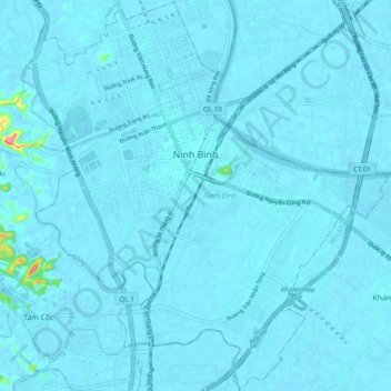
Naam: Topografische kaart Ninh Bình, hoogte, reliëf.
Locatie: Ninh Bình, Ninh Bình Province, 08000, Vietnam (20.19976 105.92706 20.29014 106.02408)
Gemiddelde hoogte: 5 m
Minimale hoogte: -7 m
Maximale hoogte: 135 m
Andere topografische kaarten
Klik op een kaart om zijn topografie, zijn hoogte en zijn reliëf te bekijken.
Scenic Viewpoint
Vietnam > Ninh Binh province > Hoa Lư District > Tam Cốc
Scenic Viewpoint, Thai Vi, Tam Cốc, Hoa Lư District, Ninh Bình Province, 08213, Vietnam
Gemiddelde hoogte: 27 m
Kim Son District
Kim Son District, Ninh Bình Province, Vietnam
Gemiddelde hoogte: 4 m
Nho Quan District
Nho Quan District, Ninh Bình Province, Vietnam
Gemiddelde hoogte: 79 m
Gia Viễn District
Vietnam > Ninh Binh province > Gia Viễn District
Gia Viễn District, Ninh Binh province, 40000, Vietnam
Gemiddelde hoogte: 17 m
Hoa Lư District
Vietnam > Ninh Binh province > Hoa Lư District
Hoa Lư District, Ninh Binh province, Vietnam
Gemiddelde hoogte: 15 m