
Topografische kaart Loughrea Municipal District
Interactieve kaart
Klik op de kaart om de hoogte weer te geven.
Over deze kaart
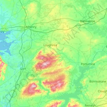
Naam: Topografische kaart Loughrea Municipal District, hoogte, reliëf.
Locatie: Loughrea Municipal District, County Galway, Connacht, Irland (52.96818 -9.05179 53.33349 -8.06208)
Gemiddelde hoogte: 69 m
Minimale hoogte: -1 m
Maximale hoogte: 392 m
Andere topografische kaarten
Klik op een kaart om zijn topografie, zijn hoogte en zijn reliëf te bekijken.
Tuam Municipal District
Tuam Municipal District, County Galway, Connacht, Irland
Gemiddelde hoogte: 54 m
Galway Bay - Cuan na Gaillimhe
Galway Bay - Cuan na Gaillimhe, County Galway, Connacht, Irland
Gemiddelde hoogte: 35 m
Knocknagoneen
Irland > County Galway > Cathair na Gaillimhe > Galway Municipal District
Knocknagoneen, Knocknacarragh, Galway Municipal District, Cathair na Gaillimhe, County Galway, Connacht, H91 R6PW, Irland
Gemiddelde hoogte: 5 m