
Topografische kaart Shahrud
Interactieve kaart
Klik op de kaart om de hoogte weer te geven.
Over deze kaart
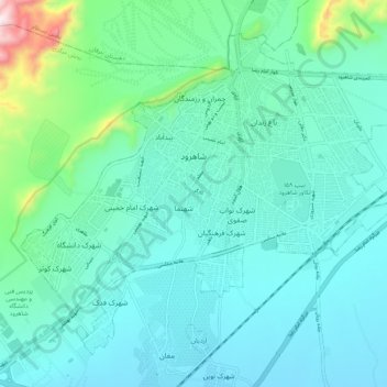
Naam: Topografische kaart Shahrud, hoogte, reliëf.
Locatie: Shahrud, بخش مرکزی, Shahrud County, Semnan Province, Iran (36.37551 54.91737 36.44660 55.02354)
Gemiddelde hoogte: 1.375 m
Minimale hoogte: 1.265 m
Maximale hoogte: 1.940 m
Situated about an altitude of 1345 m, it is located at latitude 36°25'N, longitude 055°01'E. The main launch site of the Iranian Space Agency is near Shahrood. It is also well known for unique types of grapes which are cultivated specially in Shahrud. Consequently, Shahrood is known as the City of Grapes.
Andere topografische kaarten
Klik op een kaart om zijn topografie, zijn hoogte en zijn reliëf te bekijken.
خرقان
Iran > Semnan Province > Shahrud County > دهستان خرقان
خرقان, دهستان خرقان, بخش بسطام, Shahrud County, Semnan Province, Iran
Gemiddelde hoogte: 1.514 m
دهستان طرود
Iran > Semnan Province > Shahrud County
دهستان طرود, بخش مرکزی, Shahrud County, Semnan Province, Iran
Gemiddelde hoogte: 941 m
Bastam
Iran > Semnan Province > Shahrud County > دهستان خرقان
Bastam, دهستان خرقان, بخش بسطام, Shahrud County, Semnan Province, Iran
Gemiddelde hoogte: 1.434 m
Shahrud
Iran > Semnan Province > Shahrud County > Shahrud
Shahrud, بخش مرکزی, Shahrud County, Semnan Province, Iran
Gemiddelde hoogte: 1.510 m