
Topografische kaart Mahikeng Ward 21
Interactieve kaart
Klik op de kaart om de hoogte weer te geven.
Over deze kaart
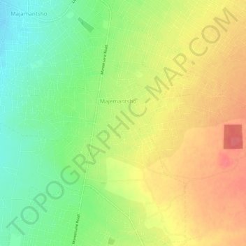
Naam: Topografische kaart Mahikeng Ward 21, hoogte, reliëf.
Gemiddelde hoogte: 1.308 m
Minimale hoogte: 1.275 m
Maximale hoogte: 1.340 m
Andere topografische kaarten
Klik op een kaart om zijn topografie, zijn hoogte en zijn reliëf te bekijken.
Mafikeng Game Reserve
RSA > North West > Mahikeng Local Municipality
Mafikeng Game Reserve, R503, Ditsobotla Ward 10, Mahikeng Local Municipality, Ngaka Modiri Molema District Municipality, North West, RSA
Gemiddelde hoogte: 1.334 m
Disaneng Dam
RSA > North West > Mahikeng Local Municipality
Disaneng Dam, Mahikeng Ward 2, Mahikeng Local Municipality, Ngaka Modiri Molema District Municipality, North West, RSA
Gemiddelde hoogte: 1.202 m
Mareetsane
RSA > North West > Mahikeng Local Municipality
Mareetsane, Mahikeng Local Municipality, Ngaka Modiri Molema District Municipality, North West, RSA
Gemiddelde hoogte: 1.330 m