
Topografische kaart Allen Jay
Interactieve kaart
Klik op de kaart om de hoogte weer te geven.
Over deze kaart
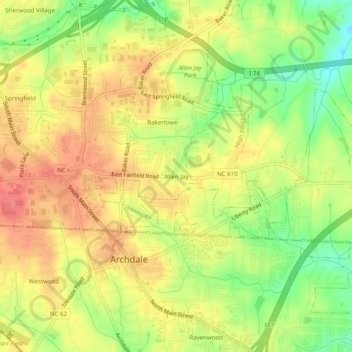
Naam: Topografische kaart Allen Jay, hoogte, reliëf.
Gemiddelde hoogte: 254 m
Minimale hoogte: 216 m
Maximale hoogte: 281 m
Andere topografische kaarten
Klik op een kaart om zijn topografie, zijn hoogte en zijn reliëf te bekijken.
Oak Hollow Lake
United States > North Carolina > Guilford County > High Point
Oak Hollow Lake, High Point, Guilford County, North Carolina, 27265, United States
Gemiddelde hoogte: 261 m
City Lake
United States > North Carolina > Guilford County > High Point
City Lake, High Point, Guilford County, North Carolina, United States
Gemiddelde hoogte: 247 m
Oakview
United States > North Carolina > Guilford County > High Point
Oakview, High Point, Guilford County, North Carolina, 27265, United States
Gemiddelde hoogte: 264 m
Owens Lake
United States > North Carolina > Guilford County > High Point
Owens Lake, High Point, Guilford County, North Carolina, United States
Gemiddelde hoogte: 255 m