
Topografische kaart Marston
Interactieve kaart
Klik op de kaart om de hoogte weer te geven.
Over deze kaart
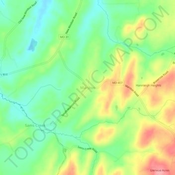
Naam: Topografische kaart Marston, hoogte, reliëf.
Locatie: Marston, Carroll County, Maryland, 21776, United States (39.48788 -77.12026 39.52788 -77.08026)
Gemiddelde hoogte: 189 m
Minimale hoogte: 143 m
Maximale hoogte: 257 m
Andere topografische kaarten
Klik op een kaart om zijn topografie, zijn hoogte en zijn reliëf te bekijken.
Eastview
United States > Maryland > Carroll County
Eastview, Carroll County, Maryland, 21048, United States
Gemiddelde hoogte: 217 m
Mount Airy
United States > Maryland > Carroll County
Mount Airy, Carroll County, Maryland, 21771, United States
Gemiddelde hoogte: 221 m
Bear Branch
United States > Maryland > Carroll County > Brown Heights
Bear Branch, Brown Heights, Carroll County, Maryland, United States
Gemiddelde hoogte: 145 m
Belle Grove Square
United States > Maryland > Carroll County > Westminster
Belle Grove Square, Westminster, Carroll County, Maryland, 21157, United States
Gemiddelde hoogte: 224 m
Finksburg
United States > Maryland > Carroll County
Finksburg, Carroll County, Maryland, 21048, United States
Gemiddelde hoogte: 158 m
Hampstead
United States > Maryland > Carroll County
Hampstead, Carroll County, Maryland, United States
Gemiddelde hoogte: 242 m
New Windsor
United States > Maryland > Carroll County
New Windsor, Carroll County, Maryland, United States
Gemiddelde hoogte: 154 m
Keymar
United States > Maryland > Carroll County
Keymar, Carroll County, Maryland, 21757, United States
Gemiddelde hoogte: 128 m
Eldersburg
United States > Maryland > Carroll County
Eldersburg, Carroll County, Maryland, 21784, United States
Gemiddelde hoogte: 166 m
Gaither
United States > Maryland > Carroll County
Gaither, Carroll County, Maryland, 21784, United States
Gemiddelde hoogte: 161 m
Union Bridge
United States > Maryland > Carroll County
Union Bridge, Carroll County, Maryland, United States
Gemiddelde hoogte: 138 m
Avondale Wildlife Management Area
United States > Maryland > Carroll County > Chapel Heights
Avondale Wildlife Management Area, Chapel Heights, Carroll County, Maryland, United States
Gemiddelde hoogte: 206 m
Melrose
United States > Maryland > Carroll County
Melrose, Carroll County, Maryland, United States
Gemiddelde hoogte: 262 m
Heritage
United States > Maryland > Carroll County
Heritage, Carroll County, Maryland, United States
Gemiddelde hoogte: 214 m
Washington Heights
United States > Maryland > Carroll County > Westminster
Washington Heights, Westminster, Carroll County, Maryland, 21157, United States
Gemiddelde hoogte: 233 m
Taneytown
United States > Maryland > Carroll County
Taneytown, Carroll County, Maryland, 21787, United States
Gemiddelde hoogte: 153 m
Millers
United States > Maryland > Carroll County
Millers, Carroll County, Maryland, 21102, United States
Gemiddelde hoogte: 266 m
Union Mills Homestead Park
United States > Maryland > Carroll County > Union Mills
Union Mills Homestead Park, Union Mills, Carroll County, Maryland, United States
Gemiddelde hoogte: 195 m
Furnace Hills
United States > Maryland > Carroll County > Westminster
Furnace Hills, Westminster, Carroll County, Maryland, 21157, United States
Gemiddelde hoogte: 211 m
Liberty Reservoir
United States > Maryland > Carroll County
Liberty Reservoir, Carroll County, Maryland, United States
Gemiddelde hoogte: 170 m
Cape Horn South
United States > Maryland > Carroll County
Cape Horn South, Carroll County, Maryland, United States
Gemiddelde hoogte: 256 m
Meadow Brook
United States > Maryland > Carroll County > Taneytown
Meadow Brook, Taneytown, Carroll County, Maryland, 21787, United States
Gemiddelde hoogte: 156 m
Woodbine
United States > Maryland > Carroll County
Woodbine, Carroll County, Maryland, 21797, United States
Gemiddelde hoogte: 182 m
Mill Stream Hills
United States > Maryland > Carroll County
Mill Stream Hills, Carroll County, Maryland, 21088, United States
Gemiddelde hoogte: 238 m
Silver Run
United States > Maryland > Carroll County
Silver Run, Carroll County, Maryland, United States
Gemiddelde hoogte: 198 m
Eldersburg
United States > Maryland > Carroll County > Eldersburg
Eldersburg, Carroll County, Maryland, 21784, United States
Gemiddelde hoogte: 167 m
Forest Hills
United States > Maryland > Carroll County > Forest Hills
Forest Hills, Carroll County, Maryland, 21157, United States
Gemiddelde hoogte: 227 m
Manchester
United States > Maryland > Carroll County
Manchester, Carroll County, Maryland, United States
Gemiddelde hoogte: 276 m
Westminster
United States > Maryland > Carroll County
Westminster, Carroll County, Maryland, United States
Gemiddelde hoogte: 226 m
Mount Airy
United States > Maryland > Carroll County > Mount Airy > Mount Airy
Mount Airy, Carroll County, Maryland, 21771, United States
Gemiddelde hoogte: 217 m
Sykesville
United States > Maryland > Carroll County
Sykesville, Carroll County, Maryland, United States
Gemiddelde hoogte: 152 m
Piney Creek
United States > Maryland > Carroll County
Piney Creek, Carroll County, Maryland, 21787, United States
Gemiddelde hoogte: 152 m