
Topografische kaart Dosquebradas
Interactieve kaart
Klik op de kaart om de hoogte weer te geven.
Over deze kaart
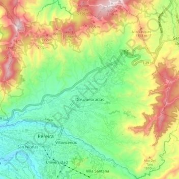
Naam: Topografische kaart Dosquebradas, hoogte, reliëf.
Gemiddelde hoogte: 1.628 m
Minimale hoogte: 1.283 m
Maximale hoogte: 2.161 m
Andere topografische kaarten
Klik op een kaart om zijn topografie, zijn hoogte en zijn reliëf te bekijken.
Pereira
Colombia > Risaralda > Pereira
Pereira is located on the central mountain range, on the Otún river valley, and part of the Cauca river valley. Pereira, like many Colombian cities, has high-elevation areas with difficult access or flat or steep parts. The streets are laid out according to the elevation of the respective zones.
Gemiddelde hoogte: 1.564 m
Santa Rosa de Cabal
Colombia > Risaralda > Santa Rosa de Cabal > Santa Rosa de Cabal
Gemiddelde hoogte: 1.769 m
Apía
Colombia > Risaralda > Apía > Apía
Apía is a town and municipality in the Department of Risaralda, Colombia. It is located at an elevation of 1,630 metres, about 60 km away from district capital Pereira in the valley of the Apia river. It has approximately 11,000 inhabitants according to the 2018 census. The town has excellent views over the…
Gemiddelde hoogte: 1.646 m