
Topografische kaart Norris
Interactieve kaart
Klik op de kaart om de hoogte weer te geven.
Over deze kaart
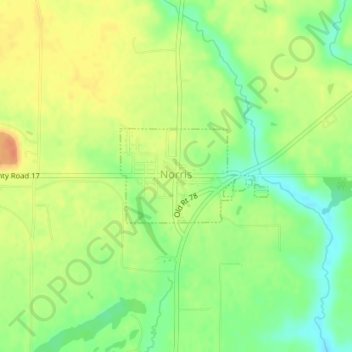
Naam: Topografische kaart Norris, hoogte, reliëf.
Locatie: Norris, Fulton County, Illinois, 61553, United States (40.62210 -90.03780 40.62936 -90.02283)
Gemiddelde hoogte: 221 m
Minimale hoogte: 199 m
Maximale hoogte: 240 m
Andere topografische kaarten
Klik op een kaart om zijn topografie, zijn hoogte en zijn reliëf te bekijken.
Bryant
United States > Illinois > Fulton County
Bryant, Fulton County, Illinois, 61519, United States
Gemiddelde hoogte: 185 m
Fiatt
United States > Illinois > Fulton County > Fiatt
Fiatt, Fulton County, Illinois, 61433, United States
Gemiddelde hoogte: 201 m
Avon
United States > Illinois > Fulton County
Avon, Fulton County, Illinois, United States
Gemiddelde hoogte: 193 m