
Topografische kaart Ballylinny
Interactieve kaart
Klik op de kaart om de hoogte weer te geven.
Over deze kaart
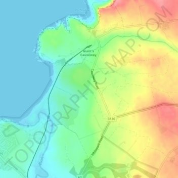
Naam: Topografische kaart Ballylinny, hoogte, reliëf.
Gemiddelde hoogte: 34 m
Minimale hoogte: -1 m
Maximale hoogte: 91 m
Andere topografische kaarten
Klik op een kaart om zijn topografie, zijn hoogte en zijn reliëf te bekijken.
Ardihannon
United Kingdom > Northern Ireland > Bushmills
Ardihannon, Bushmills, County Antrim, Northern Ireland, United Kingdom
Gemiddelde hoogte: 28 m
Castlecat
United Kingdom > Northern Ireland > Bushmills
Castlecat, Bushmills, County Antrim, Northern Ireland, United Kingdom
Gemiddelde hoogte: 57 m