
Topografische kaart Flugrath
Interactieve kaart
Klik op de kaart om de hoogte weer te geven.
Over deze kaart
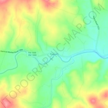
Naam: Topografische kaart Flugrath, hoogte, reliëf.
Locatie: Flugrath, Blanco County, Texas, United States of America (30.08299 -98.53975 30.12299 -98.49975)
Gemiddelde hoogte: 461 m
Minimale hoogte: 418 m
Maximale hoogte: 517 m