
Topografische kaart Winter Garden
Interactieve kaart
Klik op de kaart om de hoogte weer te geven.
Winter Garden
The terrain is characterized by a gentle to moderately sloping topography. Winter Garden has the highest elevation spot in Orange County. The highest elevation is 222 feet (68 m) in NAVD 88 (North American Vertical Datum) located in the southwest corner of the city South near the county line with Lake County. The lowest elevation in the city is 64 feet (20 m) near Lake Apopka.
Over deze kaart
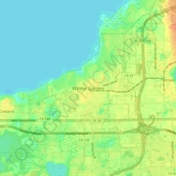
Naam: Topografische kaart Winter Garden, hoogte, reliëf.
Gemiddelde hoogte: 31 m
Minimale hoogte: 16 m
Maximale hoogte: 54 m