
Topografische kaart Municipal Unit of Nikaia
Interactieve kaart
Klik op de kaart om de hoogte weer te geven.
Over deze kaart
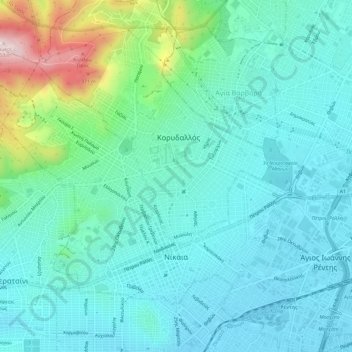
Naam: Topografische kaart Municipal Unit of Nikaia, hoogte, reliëf.
Gemiddelde hoogte: 95 m
Minimale hoogte: 5 m
Maximale hoogte: 458 m
Andere topografische kaarten
Klik op een kaart om zijn topografie, zijn hoogte en zijn reliëf te bekijken.
Keratsini
Greece > Attica > Regional Unit of Piraeus > Municipal Unit of Keratsini
Keratsini, Municipal Unit of Keratsini, Municipality of Keratsini-Drapetsona, Regional Unit of Piraeus, Attica, 187 56, Greece
Gemiddelde hoogte: 73 m
Piraeus
Greece > Attica > Regional Unit of Piraeus
Piraeus, Municipality of Piraeus, Regional Unit of Piraeus, Attica, 185 35, Greece
Gemiddelde hoogte: 96 m