
Topografische kaart Întorsura Buzăului
Interactieve kaart
Klik op de kaart om de hoogte weer te geven.
Over deze kaart
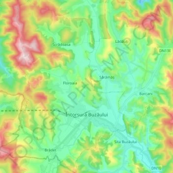
Naam: Topografische kaart Întorsura Buzăului, hoogte, reliëf.
Locatie: Întorsura Buzăului, Covasna, Romania (45.63741 25.95131 45.74807 26.06707)
Gemiddelde hoogte: 790 m
Minimale hoogte: 652 m
Maximale hoogte: 1.060 m
Întorsura Buzăului is located at 750 m (2,460 ft) altitude, in a depression, surrounded by the Întorsurii [ro], Ciucaș, and Siriu [ro] mountains. Due to its location, the town registers the lowest temperatures in Romania every year.
Andere topografische kaarten
Klik op een kaart om zijn topografie, zijn hoogte en zijn reliëf te bekijken.
Sfântu Gheorghe
Romania > Covasna > Sfântu Gheorghe
Sfântu Gheorghe, Covasna, Romania
Gemiddelde hoogte: 551 m