
Topografische kaart Zabrzeż
Interactieve kaart
Klik op de kaart om de hoogte weer te geven.
Over deze kaart
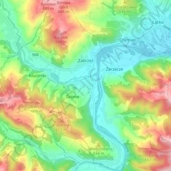
Naam: Topografische kaart Zabrzeż, hoogte, reliëf.
Gemiddelde hoogte: 479 m
Minimale hoogte: 350 m
Maximale hoogte: 706 m
Andere topografische kaarten
Klik op een kaart om zijn topografie, zijn hoogte en zijn reliëf te bekijken.
Stary Sącz
Poland > Lesser Poland Voivodeship > Nowy Sącz County
Stary Sącz, gmina Stary Sącz, Nowy Sącz County, Lesser Poland Voivodeship, 33-340, Poland
Gemiddelde hoogte: 332 m
Rachów
Poland > Lesser Poland Voivodeship > Nowy Sącz County > Tęgoborze
Rachów, Tęgoborze, gmina Łososina Dolna, Nowy Sącz County, Lesser Poland Voivodeship, 33-312, Poland
Gemiddelde hoogte: 330 m
Mszalnica
Poland > Lesser Poland Voivodeship > Nowy Sącz County
Mszalnica, gmina Kamionka Wielka, Nowy Sącz County, Lesser Poland Voivodeship, 33-334, Poland
Gemiddelde hoogte: 474 m
Ptaszkowa
Poland > Lesser Poland Voivodeship > Nowy Sącz County
Ptaszkowa, gmina Grybów, Nowy Sącz County, Lesser Poland Voivodeship, 33-333, Poland
Gemiddelde hoogte: 534 m
Święty Krzyż
Poland > Lesser Poland Voivodeship > Nowy Sącz County > Królowa Polska > Góry
Święty Krzyż, Granica, Góry, Królowa Polska, gmina Kamionka Wielka, Nowy Sącz County, Lesser Poland Voivodeship, 33-334, Poland
Gemiddelde hoogte: 463 m
Grybów
Poland > Lesser Poland Voivodeship > Nowy Sącz County > Grybów
Grybów, Nowy Sącz County, Lesser Poland Voivodeship, Poland
Gemiddelde hoogte: 433 m