
Topografische kaart Maretlwane
Interactieve kaart
Klik op de kaart om de hoogte weer te geven.
Over deze kaart
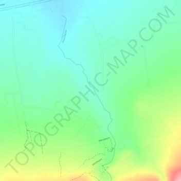
Naam: Topografische kaart Maretlwane, hoogte, reliëf.
Gemiddelde hoogte: 1.241 m
Minimale hoogte: 1.196 m
Maximale hoogte: 1.333 m
Andere topografische kaarten
Klik op een kaart om zijn topografie, zijn hoogte en zijn reliëf te bekijken.
Magaliesberg Protected Natural Environment
RSA > North West > Madibeng Local Municipality
Magaliesberg Protected Natural Environment, R560, Madibeng Ward 29, Madibeng Local Municipality, Bojanala Platinum District Municipality, North West, RSA
Gemiddelde hoogte: 1.363 m