
Topografische kaart Spencerville
Interactieve kaart
Klik op de kaart om de hoogte weer te geven.
Over deze kaart
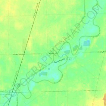
Naam: Topografische kaart Spencerville, hoogte, reliëf.
Locatie: Spencerville, DeKalb County, Indiana, 46788, United States (41.26311 -84.94191 41.30311 -84.90191)
Gemiddelde hoogte: 249 m
Minimale hoogte: 234 m
Maximale hoogte: 262 m
Andere topografische kaarten
Klik op een kaart om zijn topografie, zijn hoogte en zijn reliëf te bekijken.
Corunna
United States > Indiana > DeKalb County
Corunna, DeKalb County, Indiana, United States
Gemiddelde hoogte: 295 m
Altona
United States > Indiana > DeKalb County
Altona, DeKalb County, Indiana, United States
Gemiddelde hoogte: 271 m
Ashley
United States > Indiana > DeKalb County
Ashley, DeKalb County, Indiana, 46705, United States
Gemiddelde hoogte: 303 m
Butler
United States > Indiana > DeKalb County
Butler, DeKalb County, Indiana, United States
Gemiddelde hoogte: 265 m
St. Joe
United States > Indiana > DeKalb County
St. Joe, DeKalb County, Indiana, United States
Gemiddelde hoogte: 250 m
Waterloo
United States > Indiana > DeKalb County
Waterloo, DeKalb County, Indiana, United States
Gemiddelde hoogte: 276 m
Stafford Center
United States > Indiana > DeKalb County
Stafford Center, DeKalb County, Indiana, 46721, United States
Gemiddelde hoogte: 258 m
Garrett
United States > Indiana > DeKalb County
Garrett, DeKalb County, Indiana, 46738, United States
Gemiddelde hoogte: 270 m