
Doe een donatie
Rust jezelf uit voor je volgende avontuur:
Als Amazon-partner verdient deze site een commissie op in aanmerking komende aankopen, zonder extra kosten voor jou.
Topografische kaart Jerome
Klik op de kaart om de hoogte weer te geven.
Doe een donatie
Rust jezelf uit voor je volgende avontuur:
Als Amazon-partner verdient deze site een commissie op in aanmerking komende aankopen, zonder extra kosten voor jou.
Jerome
Jerome is about 100 miles (160 km) north of Phoenix and 45 miles (72 km) southwest of Flagstaff along Arizona State Route 89A between Sedona to the east and Prescott to the west. The town is in Arizona's Black Hills, which trend north–south. The town lies within the Prescott National Forest at an elevation of more than 5,000 feet (1,500 m). Woodchute Wilderness is about 3 miles (5 km) west of Jerome, and Mingus Mountain, at 7,726 feet (2,355 m) above sea level, is about 4 miles (6 km) south of town. Jerome State Historic Park is in the town itself. Bitter Creek, a tributary of the Verde River, flows intermittently through Jerome. East of Jerome at the base of the hills are the Verde Valley and the communities of Clarkdale and Cottonwood, site of the nearest airport.
Doe een donatie
Rust jezelf uit voor je volgende avontuur:
Als Amazon-partner verdient deze site een commissie op in aanmerking komende aankopen, zonder extra kosten voor jou.
Over deze kaart
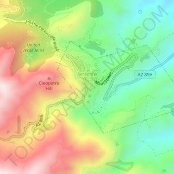
Naam: Topografische kaart Jerome, hoogte, reliëf.
Locatie: Jerome, Yavapai County, Arizona, 86331, United States (34.73958 -112.11939 34.75395 -112.09424)
Gemiddelde hoogte: 1.574 m
Minimale hoogte: 1.291 m
Maximale hoogte: 1.930 m
Doe een donatie
Rust jezelf uit voor je volgende avontuur:
Als Amazon-partner verdient deze site een commissie op in aanmerking komende aankopen, zonder extra kosten voor jou.
Andere topografische kaarten
Klik op een kaart om zijn topografie, zijn hoogte en zijn reliëf te bekijken.
Doe een donatie
Rust jezelf uit voor je volgende avontuur:
Als Amazon-partner verdient deze site een commissie op in aanmerking komende aankopen, zonder extra kosten voor jou.
Yarnell Hill Fire Memorial Park
United States > Arizona > Yavapai County > Yarnell
Gemiddelde hoogte: 1.498 m
Doe een donatie
Rust jezelf uit voor je volgende avontuur:
Als Amazon-partner verdient deze site een commissie op in aanmerking komende aankopen, zonder extra kosten voor jou.
Cathedral Rock
United States > Arizona > Yavapai County
Cathedral Rock is a natural sandstone butte near Sedona, Arizona, United States, and one of the most-photographed sights in the state. The rock formation is located in Coconino National Forest in Yavapai County, about 1 mile (1.6 km) west of State Route 179 (SR 179), and about 2.5 mi (4.0 km) south of the "Y"…
Gemiddelde hoogte: 1.282 m
Doe een donatie
Rust jezelf uit voor je volgende avontuur:
Als Amazon-partner verdient deze site een commissie op in aanmerking komende aankopen, zonder extra kosten voor jou.
Doe een donatie
Rust jezelf uit voor je volgende avontuur:
Als Amazon-partner verdient deze site een commissie op in aanmerking komende aankopen, zonder extra kosten voor jou.
Doe een donatie
Rust jezelf uit voor je volgende avontuur:
Als Amazon-partner verdient deze site een commissie op in aanmerking komende aankopen, zonder extra kosten voor jou.
Doe een donatie
Rust jezelf uit voor je volgende avontuur:
Als Amazon-partner verdient deze site een commissie op in aanmerking komende aankopen, zonder extra kosten voor jou.
Doe een donatie
Rust jezelf uit voor je volgende avontuur:
Als Amazon-partner verdient deze site een commissie op in aanmerking komende aankopen, zonder extra kosten voor jou.
Doe een donatie
Rust jezelf uit voor je volgende avontuur:
Als Amazon-partner verdient deze site een commissie op in aanmerking komende aankopen, zonder extra kosten voor jou.
Lynx Lake
United States > Arizona > Yavapai County
Lynx Lake, Arizona, is a 55-acre (220,000 m2) reservoir located within Prescott National Forest, approximately 5 miles (8.0 km) east of Prescott, Arizona, in the Bradshaw Mountains. The lake is located at 5,530 feet (1,690 m) elevation and is stocked for fishing. It is one of the most popular recreation areas…
Gemiddelde hoogte: 1.726 m
Doe een donatie
Rust jezelf uit voor je volgende avontuur:
Als Amazon-partner verdient deze site een commissie op in aanmerking komende aankopen, zonder extra kosten voor jou.
Cathedral Rock
United States > Arizona > Yavapai County
Cathedral Rock is a natural sandstone butte near Sedona, Arizona, and one of the most-photographed sights in Arizona, United States. The rock formation is located in the Coconino National Forest in Yavapai County, about 1 mi (1.6 km) west of Arizona Route 179, and about 2.5 mi (4.0 km) south of the "Y"…
Gemiddelde hoogte: 1.282 m
Arcosanti
United States > Arizona > Yavapai County
Arcosanti is a projected experimental town with a molten bronze bell casting business in Yavapai County, central Arizona, United States, 70 mi (110 km) north of Phoenix, at an elevation of 3,732 feet (1,138 m). Its arcology concept was proposed by the Italian-American architect Paolo Soleri (1919–2013). He…
Gemiddelde hoogte: 1.130 m
Doe een donatie
Rust jezelf uit voor je volgende avontuur:
Als Amazon-partner verdient deze site een commissie op in aanmerking komende aankopen, zonder extra kosten voor jou.
Doe een donatie
Rust jezelf uit voor je volgende avontuur:
Als Amazon-partner verdient deze site een commissie op in aanmerking komende aankopen, zonder extra kosten voor jou.