
Topografische kaart Taal Volcano
Interactieve kaart
Klik op de kaart om de hoogte weer te geven.
Over deze kaart
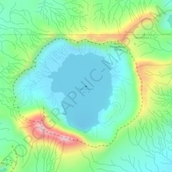
Naam: Topografische kaart Taal Volcano, hoogte, reliëf.
Gemiddelde hoogte: 91 m
Minimale hoogte: -6 m
Maximale hoogte: 281 m
Volcano Island sank from 1 to 3 m (3 to 10 ft) as a result of the eruption. It was also found that the southern shore of Lake Taal sank in elevation from the eruption. No evidences of lava could be discovered anywhere, nor have geologists been able to trace any visible records of a lava flow having occurred at any time on the volcano back then. Another peculiarity of the geologic aspects of Taal is the fact that no sulphur has been found on the volcano. The yellow deposits and encrustations noticeable in the crater and its vicinity are iron salts, according to chemical analysis. A slight smell of sulfur was perceptible at the volcano, which came from the gases that escaped from the crater.
Andere topografische kaarten
Klik op een kaart om zijn topografie, zijn hoogte en zijn reliëf te bekijken.
Pulang-Bato
Philippines > Batangas > San Nicolas
Pulang-Bato, San Nicolas, Batangas, Calabarzon, 4207, Philippines
Gemiddelde hoogte: 22 m
Taal Crater Lake
Philippines > Batangas > San Nicolas
Taal Crater Lake, San Nicolas, Batangas, Calabarzon, 4207, Philippines
Gemiddelde hoogte: 90 m
Calangay
Philippines > Batangas > San Nicolas
Calangay, San Nicolas, Batangas, Calabarzon, 4211, Philippines
Gemiddelde hoogte: 52 m
Pansipit River
Philippines > Batangas > San Nicolas > Talang
Pansipit River, Talang, San Nicolas, Batangas, Calabarzon, 4207, Philippines
Gemiddelde hoogte: 39 m
San Nicolas
Philippines > Batangas > San Nicolas
San Nicolas, Batangas, Calabarzon, 4207, Philippines
Gemiddelde hoogte: 68 m
Alas-as
Philippines > Batangas > San Nicolas > Alas-as
Alas-as, San Nicolas, Batangas, Calabarzon, Philippines
Gemiddelde hoogte: 35 m
San Nicolas
Philippines > Batangas > San Nicolas
San Nicolas, Batangas, Calabarzon, 4207, Philippines
Gemiddelde hoogte: 40 m