
Topografische kaart La Luz
Interactieve kaart
Klik op de kaart om de hoogte weer te geven.
Over deze kaart
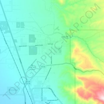
Naam: Topografische kaart La Luz, hoogte, reliëf.
Locatie: La Luz, Otero County, New Mexico, 88337, United States (32.94534 -105.98488 32.99428 -105.87564)
Gemiddelde hoogte: 1.493 m
Minimale hoogte: 1.318 m
Maximale hoogte: 2.115 m
The largest employer in the surrounding area is Holloman Air Force Base. La Luz itself is largely residential and agricultural in land use but a small market is located on the state maintained road that connects the village to Highway 70. La Luz has long been known for the many fruits that are grown in the area including figs, apricots, plums and peaches. Apples, cherries, and pears are grown in the higher elevations in the canyon areas to the east of the village. The surrounding area also has a number of vineyards and pistachio groves. A number of artists also reside in the area.
Andere topografische kaarten
Klik op een kaart om zijn topografie, zijn hoogte en zijn reliëf te bekijken.
Cloudcroft
United States > New Mexico > Otero County
Cloudcroft, Otero County, New Mexico, United States
Gemiddelde hoogte: 2.643 m
Alamorosa
United States > New Mexico > Otero County
Alamorosa, Otero County, New Mexico, 88337, United States
Gemiddelde hoogte: 1.365 m
La Luz
United States > New Mexico > Otero County
La Luz, Otero County, New Mexico, 88337, United States
Gemiddelde hoogte: 1.452 m
Orogrande
United States > New Mexico > Otero County
Orogrande, Otero County, New Mexico, 88342, United States
Gemiddelde hoogte: 1.285 m
Weed
United States > New Mexico > Otero County
Weed, Otero County, New Mexico, 88354, United States
Gemiddelde hoogte: 2.212 m
Timberon
United States > New Mexico > Otero County
Timberon, Otero County, New Mexico, 88350, United States
Gemiddelde hoogte: 2.181 m
Apache
United States > New Mexico > Otero County
Apache, Otero County, New Mexico, United States
Gemiddelde hoogte: 1.957 m
Cloudcroft
United States > New Mexico > Otero County > Cloudcroft
Cloudcroft, Otero County, New Mexico, 88317, United States
Gemiddelde hoogte: 2.636 m
White Sands National Park
United States > New Mexico > Otero County
White Sands National Park, Otero County, New Mexico, United States
Gemiddelde hoogte: 1.214 m
Alamogordo
United States > New Mexico > Otero County
Alamogordo, Otero County, New Mexico, 88310, United States
Gemiddelde hoogte: 1.644 m
Alamogordo
United States > New Mexico > Otero County
Alamogordo, Otero County, New Mexico, United States
Gemiddelde hoogte: 1.515 m
High Rolls
United States > New Mexico > Otero County
High Rolls, Otero County, New Mexico, 88325, United States
Gemiddelde hoogte: 2.036 m
Mayhill
United States > New Mexico > Otero County
Mayhill, Otero County, New Mexico, United States
Gemiddelde hoogte: 2.104 m
Sacramento
United States > New Mexico > Otero County
Sacramento, Otero County, New Mexico, 88347, United States
Gemiddelde hoogte: 2.320 m