
Topografische kaart Village of Hamilton
Interactieve kaart
Klik op de kaart om de hoogte weer te geven.
Over deze kaart
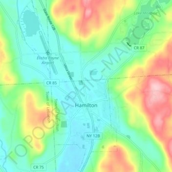
Naam: Topografische kaart Village of Hamilton, hoogte, reliëf.
Gemiddelde hoogte: 386 m
Minimale hoogte: 331 m
Maximale hoogte: 502 m
The village, located at 42°49′32″N 75°32′40″W / 42.82556°N 75.54444°W / 42.82556; -75.54444 (42.825646, -75.544673), lies in the Chenango Valley, just south of the headwaters of the Chenango River. Northeast of the village is the river Payne Brook, which starts at Lake Moraine and travels through the village before converging with the Chenango River. The village is approximately 40 miles (64 km) southeast of Syracuse and 30 miles (48 km) southwest of Utica. The elevation of the village's municipal airport (Hamilton Municipal Airport) is approximately 1,100 feet (340 m) above sea level.
Andere topografische kaarten
Klik op een kaart om zijn topografie, zijn hoogte en zijn reliëf te bekijken.
Village of Earlville
United States > New York > Madison County > Town of Hamilton
Village of Earlville, Town of Hamilton, Madison County, New York, United States
Gemiddelde hoogte: 342 m