
Topografische kaart City of Superior
Interactieve kaart
Klik op de kaart om de hoogte weer te geven.
Over deze kaart
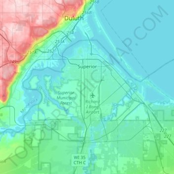
Naam: Topografische kaart City of Superior, hoogte, reliëf.
Gemiddelde hoogte: 220 m
Minimale hoogte: 177 m
Maximale hoogte: 424 m
Andere topografische kaarten
Klik op een kaart om zijn topografie, zijn hoogte en zijn reliëf te bekijken.
Solon Springs
United States > Wisconsin > Douglas County
Solon Springs, Douglas County, Wisconsin, United States
Gemiddelde hoogte: 334 m
Oliver
United States > Wisconsin > Douglas County
Oliver, Douglas County, Wisconsin, United States
Gemiddelde hoogte: 207 m
Lake Nebagamon
United States > Wisconsin > Douglas County
Lake Nebagamon, Douglas County, Wisconsin, 54849, United States
Gemiddelde hoogte: 351 m
Dairyland
United States > Wisconsin > Douglas County
Dairyland, Town of Dairyland, Douglas County, Wisconsin, United States
Gemiddelde hoogte: 339 m
Town of Maple
United States > Wisconsin > Douglas County
Town of Maple, Douglas County, Wisconsin, 54854, United States
Gemiddelde hoogte: 302 m
Bennett
United States > Wisconsin > Douglas County
Bennett, Town of Bennett, Douglas County, Wisconsin, United States
Gemiddelde hoogte: 368 m
Big Manitou Falls
United States > Wisconsin > Douglas County > Town of Superior
Big Manitou Falls, Town of Superior, Douglas County, Wisconsin, United States
Gemiddelde hoogte: 295 m
Town of Brule
United States > Wisconsin > Douglas County
Town of Brule, Douglas County, Wisconsin, 54820, United States
Gemiddelde hoogte: 327 m
South Range
United States > Wisconsin > Douglas County
South Range, Town of Parkland, Douglas County, Wisconsin, 54874, United States
Gemiddelde hoogte: 237 m
Foxboro
United States > Wisconsin > Douglas County
Foxboro, Town of Summit, Douglas County, Wisconsin, United States
Gemiddelde hoogte: 277 m
Poplar
United States > Wisconsin > Douglas County
Poplar, Douglas County, Wisconsin, 54864, United States
Gemiddelde hoogte: 305 m