
Topografische kaart Saint Andrews
Interactieve kaart
Klik op de kaart om de hoogte weer te geven.
Over deze kaart
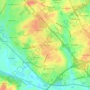
Naam: Topografische kaart Saint Andrews, hoogte, reliëf.
Gemiddelde hoogte: 76 m
Minimale hoogte: 49 m
Maximale hoogte: 106 m
Andere topografische kaarten
Klik op een kaart om zijn topografie, zijn hoogte en zijn reliëf te bekijken.
Lake Murray
United States > South Carolina > Lexington County
Lake Murray, Lexington County, South Carolina, United States
Gemiddelde hoogte: 113 m
Peachtree Rock Heritage Preserve
United States > South Carolina > Lexington County
Peachtree Rock Heritage Preserve, Green Trail, Lexington County, South Carolina, United States
Gemiddelde hoogte: 148 m
Oak Grove
United States > South Carolina > Lexington County > Lakeview Terrace
Oak Grove, Lakeview Terrace, Lexington County, South Carolina, United States
Gemiddelde hoogte: 97 m
South Congaree
United States > South Carolina > Lexington County
South Congaree, Lexington County, South Carolina, United States
Gemiddelde hoogte: 65 m
Glenn Village
United States > South Carolina > Lexington County
Glenn Village, Lexington County, South Carolina, 29172, United States
Gemiddelde hoogte: 94 m
Shady Acres
United States > South Carolina > Lexington County
Shady Acres, Lexington County, South Carolina, 29036, United States
Gemiddelde hoogte: 115 m
Gilbert
United States > South Carolina > Lexington County
Gilbert, Lexington County, South Carolina, United States
Gemiddelde hoogte: 164 m
West Columbia
United States > South Carolina > Lexington County
West Columbia, Lexington County, South Carolina, United States
Gemiddelde hoogte: 70 m
Pelion
United States > South Carolina > Lexington County
Pelion, Lexington County, South Carolina, 29123, United States
Gemiddelde hoogte: 128 m
Chapin
United States > South Carolina > Lexington County
Chapin, Lexington County, South Carolina, United States
Gemiddelde hoogte: 133 m
Batesburg
United States > South Carolina > Lexington County > Batesburg-Leesville
Batesburg, Batesburg-Leesville, Lexington County, South Carolina, 29060, United States
Gemiddelde hoogte: 186 m
Swansea
United States > South Carolina > Lexington County
Swansea, Lexington County, South Carolina, United States
Gemiddelde hoogte: 117 m
Irmo
United States > South Carolina > Lexington County
Irmo, Lexington County, South Carolina, 29212, United States
Gemiddelde hoogte: 94 m
Chapin
United States > South Carolina > Lexington County > Chapin
Chapin, Lexington County, South Carolina, 29075, United States
Gemiddelde hoogte: 129 m
Walden
United States > South Carolina > Lexington County
Walden, Lexington County, South Carolina, 29212, United States
Gemiddelde hoogte: 79 m
Lexington
United States > South Carolina > Lexington County
Lexington, Lexington County, South Carolina, United States
Gemiddelde hoogte: 115 m
Cayce
United States > South Carolina > Lexington County > Cayce
Cayce, Lexington County, South Carolina, 29033, United States
Gemiddelde hoogte: 83 m
Pine Point
United States > South Carolina > Lexington County > Pine Point
Pine Point, Lexington County, South Carolina, United States
Gemiddelde hoogte: 124 m
Edenwood
United States > South Carolina > Lexington County > Cayce > Edenwood
Edenwood, Cayce, Lexington County, South Carolina, 29033, United States
Gemiddelde hoogte: 51 m
Batesburg-Leesville
United States > South Carolina > Lexington County
Batesburg-Leesville, Lexington County, South Carolina, 29060, United States
Gemiddelde hoogte: 178 m
Gaston
United States > South Carolina > Lexington County
Gaston, Lexington County, South Carolina, United States
Gemiddelde hoogte: 139 m
Cayce
United States > South Carolina > Lexington County
Cayce, Lexington County, South Carolina, 29033, United States
Gemiddelde hoogte: 64 m