
Topografische kaart Gasherbrum II
Interactieve kaart
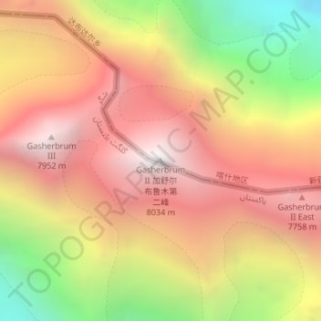
Klik op de kaart om de hoogte weer te geven.
Over deze kaart
Naam: Topografische kaart Gasherbrum II, hoogte, reliëf.
Gemiddelde hoogte: 7.098 m
Minimale hoogte: 5.846 m
Maximale hoogte: 7.992 m
Gasherbrum II is located on the border of Gilgit–Baltistan, Pakistan, and Xinjiang, China. It is part of the Karakoram mountain range in the Himalayas, and located at the top of the Baltoro Glacier. With an elevation of 8,034 metres (26,358 ft) it is the third-highest member of the Gasherbrum group, behind Gasherbrum I (8,080 metres or 26,510 feet) and Broad Peak (8,051 metres or 26,414 feet). Gasherbrum III is sometimes considered to be a subpeak of Gasherbrum II, because the former has a topographic prominence of only 461 metres (1,512 ft).
Andere topografische kaarten
Klik op een kaart om zijn topografie, zijn hoogte en zijn reliëf te bekijken.
Tashkorgan Town
China > Xinjiang > Taxkorgan Tajik Autonomous County
Tashkorgan Town, Taxkorgan Tajik Autonomous County, Kashgar Prefecture, Xinjiang, China
Gemiddelde hoogte: 3.109 m
Dafdar
China > Xinjiang > Taxkorgan Tajik Autonomous County
Dafdar, Taxkorgan Tajik Autonomous County, Kashgar Prefecture, Xinjiang, China
Gemiddelde hoogte: 4.416 m