
Topografische kaart Airedale
Interactieve kaart
Klik op de kaart om de hoogte weer te geven.
Over deze kaart
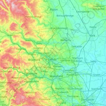
Naam: Topografische kaart Airedale, hoogte, reliëf.
Gemiddelde hoogte: 136 m
Minimale hoogte: -1 m
Maximale hoogte: 702 m
This valley is of great topographic significance as it provides low-altitude passes through the mid Pennines to the west coast known as the Aire Gap.
Andere topografische kaarten
Klik op een kaart om zijn topografie, zijn hoogte en zijn reliëf te bekijken.
Rawcliffe
United Kingdom > England > York
Rawcliffe, York, Yorkshire and the Humber, England, United Kingdom
Gemiddelde hoogte: 14 m
Hogg's Pond
United Kingdom > England > York
Hogg's Pond, Chaloners Road, Woodthorpe, York, Yorkshire and the Humber, England, YO24 2TW, United Kingdom
Gemiddelde hoogte: 14 m
Stock Hill
United Kingdom > England > York
Stock Hill, York, Yorkshire and the Humber, England, YO23 3PW, United Kingdom
Gemiddelde hoogte: 28 m