
Topografische kaart จังหวัดพระนครศรีอยุธยา
Interactieve kaart
Klik op de kaart om de hoogte weer te geven.
Over deze kaart
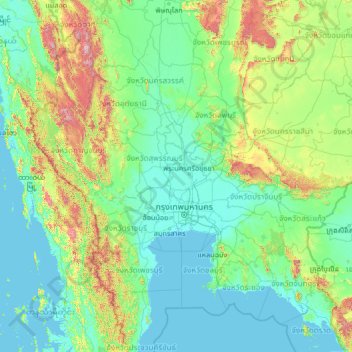
Naam: Topografische kaart จังหวัดพระนครศรีอยุธยา, hoogte, reliëf.
Locatie: จังหวัดพระนครศรีอยุธยา, Thailand (11.73807 97.81546 16.85807 102.93546)
Gemiddelde hoogte: 184 m
Minimale hoogte: -2 m
Maximale hoogte: 2.024 m
Andere topografische kaarten
Klik op een kaart om zijn topografie, zijn hoogte en zijn reliëf te bekijken.
ตำบลท่าวาสุกรี
Thailand > จังหวัดพระนครศรีอยุธยา > ตำบลท่าวาสุกรี
ตำบลท่าวาสุกรี, เทศบาลนครพระนครศรีอยุธยา, อำเภอพระนครศรีอยุธยา, จังหวัดพระนครศรีอยุธยา, 13000, Thailand
Gemiddelde hoogte: 7 m
Phra Nakhon Si Ayutthaya
Thailand > จังหวัดพระนครศรีอยุธยา > Phra Nakhon Si Ayutthaya
Phra Nakhon Si Ayutthaya, จังหวัดพระนครศรีอยุธยา, 13000, Thailand
Gemiddelde hoogte: 5 m