
Topografische kaart Fishers Island
Interactieve kaart
Klik op de kaart om de hoogte weer te geven.
Over deze kaart
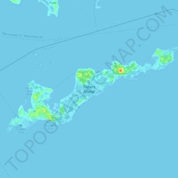
Naam: Topografische kaart Fishers Island, hoogte, reliëf.
Gemiddelde hoogte: 0 m
Minimale hoogte: -2 m
Maximale hoogte: 27 m
Andere topografische kaarten
Klik op een kaart om zijn topografie, zijn hoogte en zijn reliëf te bekijken.
New Suffolk
United States > New York > Suffolk County > Town of Southold
New Suffolk, Town of Southold, Suffolk County, New York, 11956, United States
Gemiddelde hoogte: 2 m
Cutchogue
United States > New York > Suffolk County > Town of Southold
Cutchogue, Town of Southold, Suffolk County, New York, 11935, United States
Gemiddelde hoogte: 7 m
East Marion
United States > New York > Suffolk County > Town of Southold
East Marion, Town of Southold, Suffolk County, New York, 11939, United States
Gemiddelde hoogte: 4 m
Mattituck
United States > New York > Suffolk County > Town of Southold
Mattituck, Town of Southold, Suffolk County, New York, United States
Gemiddelde hoogte: 8 m
Orient
United States > New York > Suffolk County > Town of Southold
Orient, Town of Southold, Suffolk County, New York, United States
Gemiddelde hoogte: 2 m