
Topografische kaart Borujerd City
Interactieve kaart
Klik op de kaart om de hoogte weer te geven.
Borujerd City
Borujerd city is located approximately 1670 meters above sea level and has a moderate climate with cold winters. The highest point is Garrin Mountain 3623 m above sea level and the lowest area is Gelerood River in South with 1400 m elevation. Borujerd Township has 2600 km2 area with approximately 400,000 inhabitants distributed in the city of Oshtorinan and more than 180 villages. Owing to favorable topographic and climatic conditions, the plains are devoted to cultivation of grain. Wherever irrigation is possible (by means of qanāts, wells, diversion of water of streams), cotton, melons, grapes, and fruit trees (especially almonds) are grown.
Over deze kaart
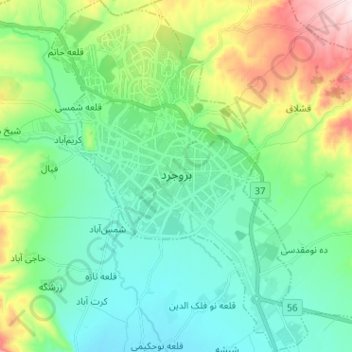
Naam: Topografische kaart Borujerd City, hoogte, reliëf.
Gemiddelde hoogte: 1.621 m
Minimale hoogte: 1.500 m
Maximale hoogte: 1.963 m
Andere topografische kaarten
Klik op een kaart om zijn topografie, zijn hoogte en zijn reliëf te bekijken.
Biatan-e Olya
Iran > Lorestan Province > Borujerd County > Oshtorinan Rural District
Gemiddelde hoogte: 2.146 m