
Topografische kaart St. Niklaus
Interactieve kaart
Klik op de kaart om de hoogte weer te geven.
Over deze kaart
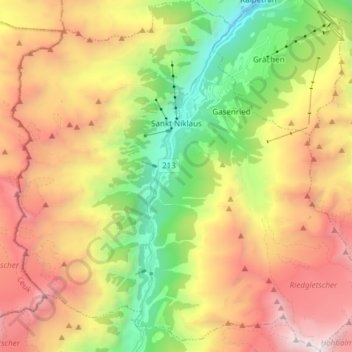
Naam: Topografische kaart St. Niklaus, hoogte, reliëf.
Locatie: St. Niklaus, Visp, Wallis, 3924, Switzerland (46.10903 7.73223 46.21347 7.88104)
Gemiddelde hoogte: 2.459 m
Minimale hoogte: 874 m
Maximale hoogte: 4.299 m
Andere topografische kaarten
Klik op een kaart om zijn topografie, zijn hoogte en zijn reliëf te bekijken.
Matterhorn
Switzerland > Wallis > Visp > Zermatt
Matterhorn, Zermatt, Visp, Wallis, 3920, Switzerland
Gemiddelde hoogte: 3.295 m
Zermatt
Switzerland > Wallis > Visp
Zermatt, Visp, Wallis, 3920, Switzerland
Gemiddelde hoogte: 2.921 m
Gobba di Rollin
Switzerland > Wallis > Visp > Zermatt
Gobba di Rollin, Zermatt, Visp, Wallis, 3920, Switzerland
Gemiddelde hoogte: 3.590 m
Monte Rosa
Switzerland > Wallis > Visp > Zermatt
Monte Rosa, Zermatt, Visp, Wallis, 3920, Switzerland
Gemiddelde hoogte: 4.033 m
Saas-Almagell
Switzerland > Wallis > Visp
Saas-Almagell, Visp, Wallis, 3905, Switzerland
Gemiddelde hoogte: 2.830 m
Mattertal
Switzerland > Wallis > Visp > St. Niklaus
Mattertal, St. Niklaus, Visp, Wallis, 3924, Switzerland
Gemiddelde hoogte: 2.434 m
Gorner Glacier
Switzerland > Wallis > Visp > Zermatt
Gorner Glacier, Zermatt, Visp, Wallis, 3920, Switzerland
Gemiddelde hoogte: 3.177 m
Dom
Switzerland > Wallis > Visp > Saas-Fee
Dom, Saas-Fee, Visp, Wallis, 3906, Switzerland
Gemiddelde hoogte: 3.785 m
Gornera
Switzerland > Wallis > Visp > Zermatt
Gornera, Zermatt, Visp, Wallis, 3920, Switzerland
Gemiddelde hoogte: 2.226 m
Saas-Fee
Switzerland > Wallis > Visp
Saas-Fee, Visp, Wallis, 3906, Switzerland
Gemiddelde hoogte: 2.673 m
Blatten
Switzerland > Wallis > Visp > Zermatt
Blatten, Zermatt, Visp, Wallis, 3920, Switzerland
Gemiddelde hoogte: 2.149 m
Grächen
Switzerland > Wallis > Visp
Grächen, Visp, Wallis, 3925, Switzerland
Gemiddelde hoogte: 1.757 m
Allalinhorn
Switzerland > Wallis > Visp > Saas-Fee
Allalinhorn, Saas-Fee, Visp, Wallis, 3906, Switzerland
Gemiddelde hoogte: 3.490 m