
Topografische kaart Choczewo
Interactieve kaart
Klik op de kaart om de hoogte weer te geven.
Over deze kaart
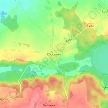
Naam: Topografische kaart Choczewo, hoogte, reliëf.
Gemiddelde hoogte: 67 m
Minimale hoogte: 32 m
Maximale hoogte: 104 m
Andere topografische kaarten
Klik op een kaart om zijn topografie, zijn hoogte en zijn reliëf te bekijken.
Reda
Poland > Pomeranian Voivodeship > Wejherowo County
Reda, Wejherowo County, Pomeranian Voivodeship, 84-240, Poland
Gemiddelde hoogte: 46 m
Jezioro Żarnowieckie
Poland > Pomeranian Voivodeship > Wejherowo County > Czymanowo
Jezioro Żarnowieckie, Czymanowo, gmina Gniewino, Wejherowo County, Pomeranian Voivodeship, 84-250, Poland
Gemiddelde hoogte: 37 m
Łęczyce
Poland > Pomeranian Voivodeship > Wejherowo County
Łęczyce, gmina Łęczyce, Wejherowo County, Pomeranian Voivodeship, Poland
Gemiddelde hoogte: 52 m
Rumia
Poland > Pomeranian Voivodeship > Wejherowo County > Rumia
Rumia, Wejherowo County, Pomeranian Voivodeship, 84-230, Poland
Gemiddelde hoogte: 69 m
Szemud
Poland > Pomeranian Voivodeship > Wejherowo County > Szemud
Szemud, gmina Szemud, Wejherowo County, Pomeranian Voivodeship, Poland
Gemiddelde hoogte: 186 m
Reda
Poland > Pomeranian Voivodeship > Wejherowo County > Reda
Reda, Wejherowo County, Pomeranian Voivodeship, 84-240, Poland
Gemiddelde hoogte: 57 m
Mierzyno
Poland > Pomeranian Voivodeship > Wejherowo County
Mierzyno, gmina Gniewino, Wejherowo County, Pomeranian Voivodeship, 84-250, Poland
Gemiddelde hoogte: 70 m
Wejherowo
Poland > Pomeranian Voivodeship > Wejherowo County > Wejherowo
Wejherowo, Wejherowo County, Pomeranian Voivodeship, Poland
Gemiddelde hoogte: 71 m