
Topografische kaart Mount Arvon
Interactieve kaart
Klik op de kaart om de hoogte weer te geven.
Over deze kaart
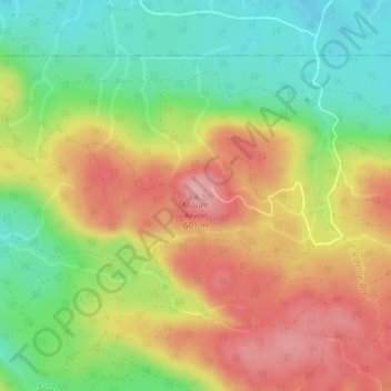
Naam: Topografische kaart Mount Arvon, hoogte, reliëf.
Gemiddelde hoogte: 526 m
Minimale hoogte: 455 m
Maximale hoogte: 600 m
Mount Arvon, elevation 1,979 feet (603 m), is the highest natural point in the U.S. state of Michigan. Located in L'Anse Township, Baraga County, Mount Arvon is part of the Huron Mountains. It rises about eight miles (13 km) south of Lake Superior (elevation 591 feet [180 m]). On the list of highest natural points in each U.S. state, Mount Arvon ranks 38th. It is the highest natural point in the East North Central states.
Andere topografische kaarten
Klik op een kaart om zijn topografie, zijn hoogte en zijn reliëf te bekijken.
L'Anse Township
United States > Michigan > Baraga County
L'Anse Township, Baraga County, Michigan, 49946, United States
Gemiddelde hoogte: 388 m
Aura
United States > Michigan > Baraga County > Aura
Aura, L'Anse Township, Baraga County, Michigan, United States
Gemiddelde hoogte: 240 m
L'Anse
United States > Michigan > Baraga County > L'Anse
L'Anse, L'Anse Township, Baraga County, Michigan, 49946, United States
Gemiddelde hoogte: 224 m
Ruth Lake
United States > Michigan > Baraga County > Three Lakes
Ruth Lake, Three Lakes, Spurr Township, Baraga County, Michigan, United States
Gemiddelde hoogte: 507 m