
Topografische kaart Winfield
Interactieve kaart
Klik op de kaart om de hoogte weer te geven.
Over deze kaart
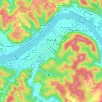
Naam: Topografische kaart Winfield, hoogte, reliëf.
Locatie: Winfield, Putnam County, West Virginia, United States (38.51452 -81.90950 38.54238 -81.85421)
Gemiddelde hoogte: 223 m
Minimale hoogte: 165 m
Maximale hoogte: 307 m
Andere topografische kaarten
Klik op een kaart om zijn topografie, zijn hoogte en zijn reliëf te bekijken.
Fraziers Bottom
United States > West Virginia > Putnam County
Fraziers Bottom, Putnam County, West Virginia, 25082, United States
Gemiddelde hoogte: 203 m
Eleanor
United States > West Virginia > Putnam County
Eleanor, Putnam County, West Virginia, 25070, United States
Gemiddelde hoogte: 213 m
Teays Villa
United States > West Virginia > Putnam County > Teays Valley
Teays Villa, Teays Valley, Putnam County, West Virginia, 25560, United States
Gemiddelde hoogte: 235 m
Pliny
United States > West Virginia > Putnam County
Pliny, Putnam County, West Virginia, 25033, United States
Gemiddelde hoogte: 212 m
Kanawha River
United States > West Virginia > Putnam County
Kanawha River, Putnam County, West Virginia, 25057, United States
Gemiddelde hoogte: 280 m
Hurricane
United States > West Virginia > Putnam County > Hurricane
Hurricane, Putnam County, West Virginia, United States
Gemiddelde hoogte: 237 m
Scott Depot
United States > West Virginia > Putnam County
Scott Depot, Putnam County, West Virginia, 25560, United States
Gemiddelde hoogte: 236 m
Teays Valley
United States > West Virginia > Putnam County
Teays Valley, Putnam County, West Virginia, United States
Gemiddelde hoogte: 242 m