
Doe een donatie
Rust jezelf uit voor je volgende avontuur:
Als Amazon-partner verdient deze site een commissie op in aanmerking komende aankopen, zonder extra kosten voor jou.
Topografische kaart Larissa
Klik op de kaart om de hoogte weer te geven.
Doe een donatie
Rust jezelf uit voor je volgende avontuur:
Als Amazon-partner verdient deze site een commissie op in aanmerking komende aankopen, zonder extra kosten voor jou.
Over deze kaart
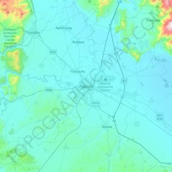
Naam: Topografische kaart Larissa, hoogte, reliëf.
Gemiddelde hoogte: 128 m
Minimale hoogte: 47 m
Maximale hoogte: 1.073 m
Doe een donatie
Rust jezelf uit voor je volgende avontuur:
Als Amazon-partner verdient deze site een commissie op in aanmerking komende aankopen, zonder extra kosten voor jou.
Andere topografische kaarten
Klik op een kaart om zijn topografie, zijn hoogte en zijn reliëf te bekijken.
Elassona Municipality
Greece > Thessaly and Central Greece > Larisa Regional Unit
Its geography includes farmlands in the valley areas, the mountains to the west and east and forests in the west and east as well as grasslands, ledges are to be founded in some areas and barren area in the higher elevations.
Gemiddelde hoogte: 644 m
Farsala Municipality
Greece > Thessaly and Central Greece > Larisa Regional Unit
The Pharsalos of the historic era was built over a hillside of the Narthacius mountains at an elevation of some 160 m, where modern Farsala stands. It was one of the main cities in Thessaly and was the capital of the Phthian tetrarch. It was also a polis (city-state).
Gemiddelde hoogte: 292 m