
Topografische kaart Libby
Interactieve kaart
Klik op de kaart om de hoogte weer te geven.
Over deze kaart
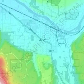
Naam: Topografische kaart Libby, hoogte, reliëf.
Locatie: Libby, Lincoln County, Montana, United States (48.36478 -115.57527 48.40918 -115.54286)
Gemiddelde hoogte: 676 m
Minimale hoogte: 617 m
Maximale hoogte: 970 m
According to the United States Census Bureau, the city has an area of 1.95 square miles (5.05 km2), of which 1.91 square miles (4.95 km2) is land and 0.04 square miles (0.10 km2) is water. Libby is in the Kootenai National Forest, between the Cabinet Mountains to the south and the Purcell Mountains to the north, the town lies in the heart of the Kootenai Valley along the Kootenai River, and downstream from the Libby Dam. Libby is at an elevation of 2,096 feet (640 m) above sea level.
Andere topografische kaarten
Klik op een kaart om zijn topografie, zijn hoogte en zijn reliëf te bekijken.
Eureka
United States > Montana > Lincoln County
Eureka, Lincoln County, Montana, United States
Gemiddelde hoogte: 832 m
Troy
United States > Montana > Lincoln County
Troy, Lincoln County, Montana, United States
Gemiddelde hoogte: 729 m
Mount Conner
United States > Montana > Lincoln County
Mount Conner, Lincoln County, Montana, United States
Gemiddelde hoogte: 1.698 m
Elk Mountain
United States > Montana > Lincoln County
Elk Mountain, Lincoln County, Montana, United States
Gemiddelde hoogte: 1.751 m
Yaak
United States > Montana > Lincoln County > Yaak
Yaak, Lincoln County, Montana, United States
Gemiddelde hoogte: 993 m
Fortine
United States > Montana > Lincoln County > Fortine
Fortine, Lincoln County, Montana, United States
Gemiddelde hoogte: 924 m
Trego
United States > Montana > Lincoln County
Trego, Lincoln County, Montana, 59934, United States
Gemiddelde hoogte: 974 m