
Topografische kaart Miesbach
Interactieve kaart
Klik op de kaart om de hoogte weer te geven.
Miesbach
Miesbach (German: [ˈmiːsˌbax] (listen)) is a town in Bavaria, Germany, and is the capital of the Miesbach district. The district is at an altitude of 697 metres above sea level. It covers an area of approximately 863.50 km² of alpine headlands and in 2017 had a population of 11,477. The town is located 48 km southeast of Munich. Lake Schliersee and Lake Tegernsee, around which are the internationally renowned spas, Bad Wiessee, Rottach-Egern and Tegernsee, are nearby. Miesbach was founded around the year 1000 and was for hundreds of years the seat of the County of Hohenwaldeck. In the 19th century it became the center of the conservation movement for the traditional costumes, the Tracht. Miesbach also has a rich history as a pilgrimage and a mining village, which can still be seen in the city landscape.
Over deze kaart
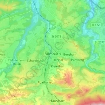
Naam: Topografische kaart Miesbach, hoogte, reliëf.
Locatie: Miesbach, Landkreis Miesbach, Bavaria, 83714, Germany (47.75656 11.77485 47.82548 11.90514)
Gemiddelde hoogte: 739 m
Minimale hoogte: 606 m
Maximale hoogte: 1.054 m
Andere topografische kaarten
Klik op een kaart om zijn topografie, zijn hoogte en zijn reliëf te bekijken.