
Topografische kaart Zaragoza
Interactieve kaart
Klik op de kaart om de hoogte weer te geven.
Over deze kaart
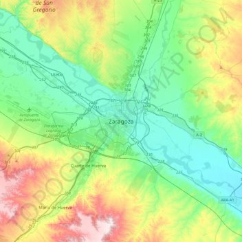
Naam: Topografische kaart Zaragoza, hoogte, reliëf.
Locatie: Zaragoza, Aragon, 50001, Spain (41.49213 -1.04094 41.81213 -0.72094)
Gemiddelde hoogte: 310 m
Minimale hoogte: 169 m
Maximale hoogte: 646 m
On 1 January 2019 the population of the municipality of Zaragoza was 706,904, (the fifth most populated in Spain) on a land area of 973.78 square kilometres (375.98 square miles). The population of the metropolitan area was estimated in 2006 at 783,763 inhabitants. The municipality is home to more than 50 percent of the Aragonese population. The city lies at an elevation of about 208 metres (682 feet) above sea level.