
Topografische kaart Sumner Lake State Park
Interactieve kaart
Klik op de kaart om de hoogte weer te geven.
Sumner Lake State Park
The park features a large 4,500-acre (18 km2) reservoir on the Pecos River, created in 1939 by the Sumner Dam of the United States Bureau of Reclamation. The reservoir is home to various fish species including largemouth bass, catfish, crappie and walleye. The park elevation is 4,300 feet (1,300 m) above sea level. With its campground, expansive views of the sky, and its distance from other cities, Sumner Lake State Park has a low level of light pollution, which makes the state park a great potential place for amateur astronomy.
Over deze kaart
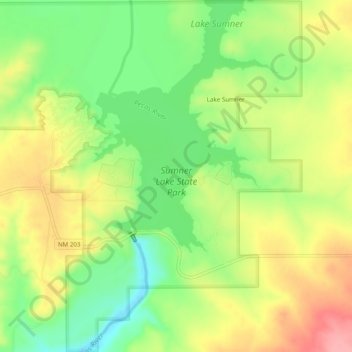
Naam: Topografische kaart Sumner Lake State Park, hoogte, reliëf.
Gemiddelde hoogte: 1.311 m
Minimale hoogte: 1.262 m
Maximale hoogte: 1.364 m
Andere topografische kaarten
Klik op een kaart om zijn topografie, zijn hoogte en zijn reliëf te bekijken.
Fort Sumner
United States > New Mexico > De Baca County
In the 1920s the Transcontinental Air Transport airline built an airfield in Fort Sumner as part of its coast-to-coast air passenger network, but the site was abandoned when the airline's ambitious plans collapsed in the Great Depression. The airfield was reopened by the United States Army Air Forces as a…
Gemiddelde hoogte: 1.242 m