
Topografische kaart Ramsgate
Interactieve kaart
Klik op de kaart om de hoogte weer te geven.
Over deze kaart
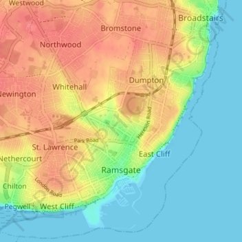
Naam: Topografische kaart Ramsgate, hoogte, reliëf.
Locatie: Ramsgate, Thanet, Kent, England, United Kingdom (51.32210 1.37687 51.36087 1.44107)
Gemiddelde hoogte: 25 m
Minimale hoogte: 0 m
Maximale hoogte: 55 m
In 2017 Ramsgate was chosen as one of the first ten Heritage Action Zones (HAZ) by Historic England, with the aim of stimulating economic growth using Ramsgate's historic environment as a catalyst. Part of this project included a Historic Landscape Characterisation Study which assessed and mapped the patterns of historic character in the town, using geological and topographical surveys, and covering aspects from the Neolithic, medieval, Georgian, Victorian, and through to the First and Second World War periods.
Andere topografische kaarten
Klik op een kaart om zijn topografie, zijn hoogte en zijn reliëf te bekijken.
Broadstairs
United Kingdom > England > Kent > Thanet
Broadstairs, Thanet, Kent, England, CT10 1LH, United Kingdom
Gemiddelde hoogte: 14 m
St Nicholas-at-Wade
United Kingdom > England > Kent > Thanet
St Nicholas-at-Wade, Thanet, Kent, England, United Kingdom
Gemiddelde hoogte: 8 m
Margate
United Kingdom > England > Kent > Thanet
Margate, Thanet, Kent, England, United Kingdom
Gemiddelde hoogte: 22 m