
Doe een donatie
Rust jezelf uit voor je volgende avontuur:
Als Amazon-partner verdient deze site een commissie op in aanmerking komende aankopen, zonder extra kosten voor jou.
Topografische kaart Borsec
Klik op de kaart om de hoogte weer te geven.
Doe een donatie
Rust jezelf uit voor je volgende avontuur:
Als Amazon-partner verdient deze site een commissie op in aanmerking komende aankopen, zonder extra kosten voor jou.
Borsec
Borsec, a resort chiefly known for its mineral water and favourable climate, is situated in the intracarpatic depression of the same name, at an altitude of 900 m (3,000 ft). The Borsec Depression has an oval shape and is northeast oriented, being separated from the hilltop of the Rotunda Chair in two subunits. The locality is composed of two areas that correspond geographically to the two small depression areas that join: The Upper Borsec (Borsec de Sus) and The Lower Borsec (Borsec de Jos). The latter is southwest along national road DN15 [ro] at its junction with county road DJ128 Borsec-Ditrău, and Borsec de Sus (or the resort itself) is located on the plateau located northeast of the primary settlement, which is at higher altitude on average with 80–100 m. In the west, at a short distance, one can reach Toplița, the Pass of Creangă and to the east the Bistricioara valley. The Borsec depression is located at a higher altitude to that of Giurgeu but lower than that of Bilbor. Within the resort there are alleys and tourist trails, most of which are located in the outskirts of the resort, especially for visiting the nature monuments from the reservation of the Scaunul Rotund and Făget (Bükkhavas). They have the necessary arrangements to perform the field treatment under appropriate conditions, including tourist markings.
Doe een donatie
Rust jezelf uit voor je volgende avontuur:
Als Amazon-partner verdient deze site een commissie op in aanmerking komende aankopen, zonder extra kosten voor jou.
Over deze kaart
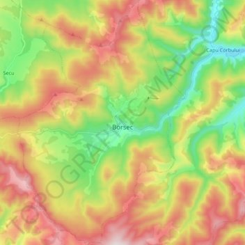
Naam: Topografische kaart Borsec, hoogte, reliëf.
Locatie: Borsec, Harghita, 535300, Romania (46.90908 25.48896 47.02268 25.60373)
Gemiddelde hoogte: 1.053 m
Minimale hoogte: 712 m
Maximale hoogte: 1.464 m
Doe een donatie
Rust jezelf uit voor je volgende avontuur:
Als Amazon-partner verdient deze site een commissie op in aanmerking komende aankopen, zonder extra kosten voor jou.
Andere topografische kaarten
Klik op een kaart om zijn topografie, zijn hoogte en zijn reliëf te bekijken.
Carpathian Mountains
The northwestern Carpathians begin in Slovakia and southern Poland. They surround Transcarpathia and Transylvania in a large semicircle, sweeping towards the southeast, and end on the Danube near Orșova in Romania. The total length of the Carpathians is over 1,500 km (930 mi). The mountain chain's width…
Gemiddelde hoogte: 980 m
Doe een donatie
Rust jezelf uit voor je volgende avontuur:
Als Amazon-partner verdient deze site een commissie op in aanmerking komende aankopen, zonder extra kosten voor jou.
Doe een donatie
Rust jezelf uit voor je volgende avontuur:
Als Amazon-partner verdient deze site een commissie op in aanmerking komende aankopen, zonder extra kosten voor jou.
Doe een donatie
Rust jezelf uit voor je volgende avontuur:
Als Amazon-partner verdient deze site een commissie op in aanmerking komende aankopen, zonder extra kosten voor jou.
Doe een donatie
Rust jezelf uit voor je volgende avontuur:
Als Amazon-partner verdient deze site een commissie op in aanmerking komende aankopen, zonder extra kosten voor jou.
Doe een donatie
Rust jezelf uit voor je volgende avontuur:
Als Amazon-partner verdient deze site een commissie op in aanmerking komende aankopen, zonder extra kosten voor jou.
Doe een donatie
Rust jezelf uit voor je volgende avontuur:
Als Amazon-partner verdient deze site een commissie op in aanmerking komende aankopen, zonder extra kosten voor jou.
Băile Tușnad
With a population of 1,617, it is the smallest town in Romania by population. It is located at an altitude of 650 metres in the southern reaches of the Ciuc depression, between the Harghita and Bodoc mountains, in the valley of the Olt, and is to this day an important spa town. The town administers one…
Gemiddelde hoogte: 833 m
Doe een donatie
Rust jezelf uit voor je volgende avontuur:
Als Amazon-partner verdient deze site een commissie op in aanmerking komende aankopen, zonder extra kosten voor jou.