
Topografische kaart Chowan River
Interactieve kaart
Klik op de kaart om de hoogte weer te geven.
Over deze kaart
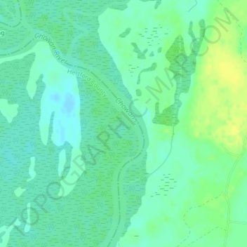
Naam: Topografische kaart Chowan River, hoogte, reliëf.
Gemiddelde hoogte: 7 m
Minimale hoogte: -1 m
Maximale hoogte: 17 m
Andere topografische kaarten
Klik op een kaart om zijn topografie, zijn hoogte en zijn reliëf te bekijken.
Wilson Creek
United States of America > North Carolina
Wilson Creek, Caldwell County, North Carolina, United States of America
Gemiddelde hoogte: 515 m
Orange County
United States of America > North Carolina
Orange County, North Carolina, United States of America
Gemiddelde hoogte: 167 m
Deep River
United States of America > North Carolina > High Point > Deep River
Deep River, High Point, Guilford County, North Carolina, 27282, United States of America
Gemiddelde hoogte: 261 m
Millers Creek
United States of America > North Carolina
Millers Creek, Duplin County, North Carolina, 28453, United States of America
Gemiddelde hoogte: 36 m
Pilot Mountain
United States of America > North Carolina
Pilot Mountain, Surry County, North Carolina, 27043, United States of America
Gemiddelde hoogte: 414 m
Sandy Plain
United States of America > North Carolina > Sandy Plain
Sandy Plain, Wake County, North Carolina, 27522, United States of America
Gemiddelde hoogte: 92 m
Rockview
United States of America > North Carolina > Rockview
Rockview, Buncombe County, North Carolina, 28709, United States of America
Gemiddelde hoogte: 837 m
Firestone
United States of America > North Carolina > Charlotte > Firestone
Firestone, Charlotte, Mecklenburg County, North Carolina, 28216, United States of America
Gemiddelde hoogte: 238 m
Wakulla
United States of America > North Carolina > Wakulla
Wakulla, Robeson County, North Carolina, United States of America
Gemiddelde hoogte: 65 m
Fisher Branch
United States of America > North Carolina
Fisher Branch, Madison County, North Carolina, 28743, United States of America
Gemiddelde hoogte: 1.048 m
Pisgah Forest
United States of America > North Carolina > Pisgah Forest
Pisgah Forest, Transylvania County, North Carolina, 28768, United States of America
Gemiddelde hoogte: 664 m