
Topografische kaart دهستان کذاب
Interactieve kaart
Klik op de kaart om de hoogte weer te geven.
Over deze kaart
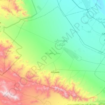
Naam: Topografische kaart دهستان کذاب, hoogte, reliëf.
Locatie: دهستان کذاب, بخش خضرآباد, Ashkezar County, Yazd Province, Iran (31.75655 53.70224 32.13434 54.21195)
Gemiddelde hoogte: 1.680 m
Minimale hoogte: 1.095 m
Maximale hoogte: 3.359 m
Andere topografische kaarten
Klik op een kaart om zijn topografie, zijn hoogte en zijn reliëf te bekijken.
Shamsi
Iran > Yazd Province > Ashkezar County > دهستان رستاق
Shamsi, دهستان رستاق, بخش مرکزی اشکذر, Ashkezar County, Yazd Province, Iran
Gemiddelde hoogte: 1.138 m