
Topografische kaart Bușteni
Interactieve kaart
Klik op de kaart om de hoogte weer te geven.
Bușteni
Bușteni (Romanian pronunciation: [buʃˈtenʲ]) is a small mountain town in the north of Prahova County, Muntenia, Romania. It is located in the Prahova Valley, at the bottom of the Bucegi Mountains, that have a maximum altitude of 2,505 m (8,219 ft). Its name literally means tree-logs in Romanian. One village, Poiana Țapului, is administratively part of the town, formerly a separate commune prior to 1950. According to the 2011 census, it has 8,894 inhabitants.
Over deze kaart
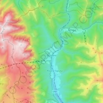
Naam: Topografische kaart Bușteni, hoogte, reliëf.
Locatie: Bușteni, Prahova, Romania (45.36783 25.45256 45.47040 25.62365)
Gemiddelde hoogte: 1.419 m
Minimale hoogte: 807 m
Maximale hoogte: 2.500 m
Andere topografische kaarten
Klik op een kaart om zijn topografie, zijn hoogte en zijn reliëf te bekijken.