
Topografische kaart Shire of Mornington Peninsula
Interactieve kaart
Klik op de kaart om de hoogte weer te geven.
Over deze kaart
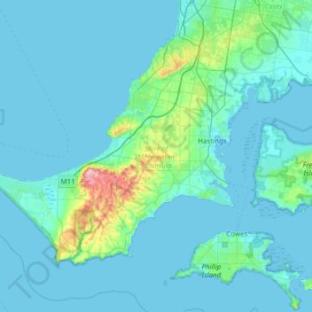
Naam: Topografische kaart Shire of Mornington Peninsula, hoogte, reliëf.
Locatie: Shire of Mornington Peninsula, Victoria, Australie (-38.49993 144.65121 -38.16259 145.26181)
Gemiddelde hoogte: 23 m
Minimale hoogte: -1 m
Maximale hoogte: 309 m
Andere topografische kaarten
Klik op een kaart om zijn topografie, zijn hoogte en zijn reliëf te bekijken.
Wilsons Promontory
Wilsons Promontory, Shire of South Gippsland, Victoria, 3960, Australie
Gemiddelde hoogte: 38 m
Melbourne Water Pipe Reserve
Australie > Victoria > Melbourne
Melbourne Water Pipe Reserve, Nunawading, Melbourne, City of Whitehorse, Victoria, Australie
Gemiddelde hoogte: 133 m
Melbourne-Sud
Australie > Victoria > Melbourne
Melbourne-Sud, Melbourne, City of Port Phillip, Victoria, 3205, Australie
Gemiddelde hoogte: 9 m
Mount Napier
Mount Napier, Shire of Southern Grampians, Victoria, Australie
Gemiddelde hoogte: 213 m
Burwood District
Australie > Victoria > Melbourne > Burwood
Burwood District, Burwood, Melbourne, City of Whitehorse, Victoria, 3125, Australie
Gemiddelde hoogte: 73 m
Melbourne District
Australie > Victoria > Melbourne
Melbourne District, Melbourne, City of Melbourne, Victoria, Australie
Gemiddelde hoogte: 20 m
Shire of South Gippsland
Shire of South Gippsland, Victoria, Australie
Gemiddelde hoogte: 81 m
Bacchus Marsh
Australie > Victoria > Bacchus Marsh
Bacchus Marsh, Shire of Moorabool, Victoria, 3340, Australie
Gemiddelde hoogte: 133 m
Shire of Yarra Ranges
Shire of Yarra Ranges, Victoria, Australie
Gemiddelde hoogte: 440 m
St Andrews Beach
St Andrews Beach, Shire of Mornington Peninsula, Victoria, Australie
Gemiddelde hoogte: 10 m
Tidal River
Tidal River, Shire of South Gippsland, Victoria, Australie
Gemiddelde hoogte: 146 m
Falls Creek
Australie > Victoria > Falls Creek Alpine Resort
Falls Creek, Falls Creek Alpine Resort, Victoria, 3699, Australie
Gemiddelde hoogte: 1.459 m
Mornington
Australie > Victoria > Mornington
Mornington, Shire of Mornington Peninsula, Victoria, 3931, Australie
Gemiddelde hoogte: 44 m
Grampians NP
Grampians NP, Glenelg River Road, Halls Gap, Shire of Southern Grampians, Grampians, Victoria, Australie
Gemiddelde hoogte: 262 m
City of Boroondara
City of Boroondara, Victoria, Australie
Gemiddelde hoogte: 53 m
Triplet Falls
Triplet Falls, Shire of Colac Otway, Barwon South West, Victoria, Australie
Gemiddelde hoogte: 366 m
Cook Creek
Cook Creek, Shire of Hepburn, Grampians, Victoria, Australie
Gemiddelde hoogte: 339 m
Great Otway National Park
Australie > Victoria > Forrest
Great Otway National Park, Kaanglang Road, Forrest, Shire of Colac Otway, Barwon South West, Victoria, 3236, Australie
Gemiddelde hoogte: 111 m
Nigretta Falls
Nigretta Falls, Shire of Southern Grampians, Barwon South West, Victoria, Australie
Gemiddelde hoogte: 171 m
Cape Schanck
Cape Schanck, Shire of Mornington Peninsula, Victoria, Australie
Gemiddelde hoogte: 83 m
Mornington District
Australie > Victoria > Melbourne
Mornington District, Melbourne, Shire of Mornington Peninsula, Victoria, Australie
Gemiddelde hoogte: 50 m
Shire of Corangamite
Shire of Corangamite, Victoria, Australie
Gemiddelde hoogte: 151 m
Mount Sunday
Mount Sunday, Shire of Mansfield, Hume, Victoria, Australie
Gemiddelde hoogte: 1.141 m
Pentland Hills
Australie > Victoria > Pentland Hills
Pentland Hills, Shire of Moorabool, Grampians, Victoria, 3341, Australie
Gemiddelde hoogte: 293 m
Mount Dandenong
Australie > Victoria > Montrose
Mount Dandenong, Montrose, Shire of Yarra Ranges, Victoria, 3765, Australie
Gemiddelde hoogte: 429 m