
Topografische kaart Scopello
Interactieve kaart
Klik op de kaart om de hoogte weer te geven.
Scopello
Scopello is a comune (municipality) located in the Valsesia region of the Italian Pennine Alps, administratively in the Province of Vercelli, Piedmont. The municipality covers an area of 18.62 square kilometres (7.19 sq mi) and ranges in elevation from 640 to 1,930 metres (2,100 to 6,330 ft) above sea level. It takes its name from its main centre, the small town of Scopello, which stands on the river Sesia at an elevation of 659 metres (2,162 ft).
Over deze kaart
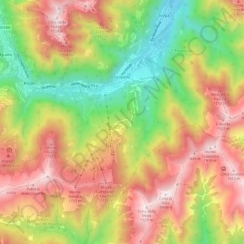
Naam: Topografische kaart Scopello, hoogte, reliëf.
Locatie: Scopello, Vercelli, Piedmont, 13028, Italy (45.71875 8.05898 45.79749 8.14081)
Gemiddelde hoogte: 1.256 m
Minimale hoogte: 595 m
Maximale hoogte: 1.935 m
Andere topografische kaarten
Klik op een kaart om zijn topografie, zijn hoogte en zijn reliëf te bekijken.