
Topografische kaart North Bergen
Interactieve kaart
Klik op de kaart om de hoogte weer te geven.
Over deze kaart
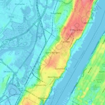
Naam: Topografische kaart North Bergen, hoogte, reliëf.
Gemiddelde hoogte: 22 m
Minimale hoogte: -5 m
Maximale hoogte: 102 m
North Bergen has diverse geological features. Partially situated on the Hudson River, the Hudson Palisades rise from the waterfront, while the northern part of the town sits atop the plateau. The cuesta, or slope, on its west side makes North Bergen the city with the second-most hills per square mile in the United States after San Francisco, some of which are extremely steep. A rock formation along the slope (located at 40°48′27″N 74°01′05″W / 40.80750°N 74.01806°W / 40.80750; -74.01806 (Rock formation in North Bergen)) is composed of unusual serpentinite rock and made up of small rock cliffs. Because of this, it is one of the few undeveloped parts of North Bergen. Low-lying areas along the west side are part of the New Jersey Meadowlands. The unusual shape and diverse topography of North Bergen have created diverse historical and contemporary neighborhoods: