
Topografische kaart Eldorado
Interactieve kaart
Klik op de kaart om de hoogte weer te geven.
Over deze kaart
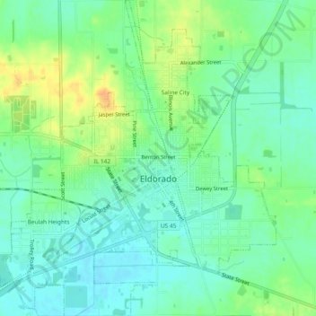
Naam: Topografische kaart Eldorado, hoogte, reliëf.
Locatie: Eldorado, Saline County, Illinois, 62930, United States (37.79766 -88.46560 37.83427 -88.42082)
Gemiddelde hoogte: 125 m
Minimale hoogte: 112 m
Maximale hoogte: 146 m
Andere topografische kaarten
Klik op een kaart om zijn topografie, zijn hoogte en zijn reliëf te bekijken.
Cornerville
United States > Illinois > Saline County
Cornerville, Saline County, Illinois, United States
Gemiddelde hoogte: 142 m
Galatia
United States > Illinois > Saline County
Galatia, Saline County, Illinois, 62935, United States
Gemiddelde hoogte: 129 m
Garden Of the Gods
United States > Illinois > Saline County
Garden Of the Gods, Saline County, Illinois, 62947, United States
Gemiddelde hoogte: 194 m
Harrisburg
United States > Illinois > Saline County
Harrisburg, Saline County, Illinois, 62946, United States
Gemiddelde hoogte: 115 m
Derby
United States > Illinois > Saline County
Derby, Saline County, Illinois, 62947, United States
Gemiddelde hoogte: 155 m
Harrisburg
United States > Illinois > Saline County > Harrisburg
Harrisburg, Saline County, Illinois, 62946:62959, United States
Gemiddelde hoogte: 115 m