
Topografische kaart West Cork
Interactieve kaart
Klik op de kaart om de hoogte weer te geven.
Over deze kaart
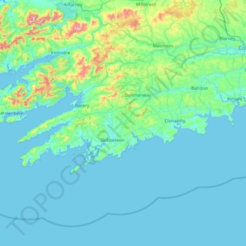
Naam: Topografische kaart West Cork, hoogte, reliëf.
Locatie: West Cork, County Cork, Munster, Irland (51.38887 -10.30252 51.83673 -8.80738)
Gemiddelde hoogte: 83 m
Minimale hoogte: 0 m
Maximale hoogte: 971 m
Andere topografische kaarten
Klik op een kaart om zijn topografie, zijn hoogte en zijn reliëf te bekijken.
The Municipal District of Kanturk – Mallow
The Municipal District of Kanturk – Mallow, County Cork, Munster, Irland
Gemiddelde hoogte: 182 m
Tullagreen
Irland > County Cork > Municipal District of Cobh
Tullagreen, Carrigtohill ED, Municipal District of Cobh, County Cork, Munster, Irland
Gemiddelde hoogte: 12 m