Geolokaliseren

Topografische kaart Logan Village

Klik op de kaart om de hoogte weer te geven.

Over deze kaart

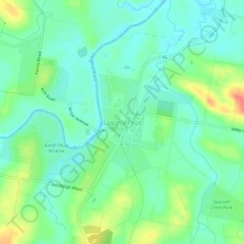
Naam: Topografische kaart Logan Village, hoogte, reliëf.

Locatie: Logan Village, Greater Brisbane, Queensland, Australia (-27.78755 153.08701 -27.74755 153.12701)

Gemiddelde hoogte: 22 m

Minimale hoogte: 4 m

Maximale hoogte: 61 m

Andere topografische kaarten

Klik op een kaart om zijn topografie, zijn hoogte en zijn reliëf te bekijken.

Moreton Bay Regional

Australia > Queensland

Gemiddelde hoogte: 110 m

Brisbane

Australia > Queensland

Gemiddelde hoogte: 87 m

Gold Coast City

Australia > Queensland

Gemiddelde hoogte: 87 m

Taringa

Australia > Queensland

Gemiddelde hoogte: 26 m

Pittsworth

Australia > Queensland

Gemiddelde hoogte: 503 m

Clermont

Australia > Queensland

Gemiddelde hoogte: 311 m

Upper Coomera

Australia > Queensland

Gemiddelde hoogte: 43 m

Coomera

Australia > Queensland > Gold Coast City

Gemiddelde hoogte: 13 m

Great Dividing Range

Australia > Queensland

Gemiddelde hoogte: 939 m

Toohey Forest

Australia > Queensland > Brisbane City

Gemiddelde hoogte: 74 m

City of Brisbane

Australia > Queensland

Brisbane's topography is characterized by a series of hills and ranges that define its landscape. The city is situated on a low-lying floodplain, with the Brisbane River meandering through its heart, creating a winding course with many steep curves from the southwest to its mouth at Moreton Bay in the east.…

Gemiddelde hoogte: 71 m

Sunshine Coast Regional

Australia > Queensland

The Sunshine Coast Regional area in Queensland, Australia, features a diverse topography that ranges from coastal plains to rugged hinterlands. Along the coastline, the terrain is predominantly flat, with average elevations around 20 meters (66 feet) above sea level. Inland, the landscape transitions to…

Gemiddelde hoogte: 56 m

Everton Park

Australia > Queensland > City of Brisbane

Gemiddelde hoogte: 51 m

Cape Tribulation

Australia > Queensland

Gemiddelde hoogte: 202 m

Mitchelton

Australia > Queensland > City of Brisbane

Gemiddelde hoogte: 55 m

Bargara

Australia > Queensland > Bundaberg Region

Gemiddelde hoogte: 8 m

Main Range National Park

Australia > Queensland

Gemiddelde hoogte: 537 m

Wivenhoe Dam

Australia > Queensland

Gemiddelde hoogte: 62 m

Kedron

Australia > Queensland

Gemiddelde hoogte: 28 m

Cungulla

Australia > Queensland

Gemiddelde hoogte: 4 m

Redcliffe

Australia > Queensland

Gemiddelde hoogte: 9 m

Kelso

Australia > Queensland

Gemiddelde hoogte: 30 m

Runcorn

Australia > Queensland

Gemiddelde hoogte: 60 m

Lawnton

Australia > Queensland

Gemiddelde hoogte: 19 m

Spring Hill

Australia > Queensland

Gemiddelde hoogte: 25 m

Eungella

Australia > Queensland

Gemiddelde hoogte: 726 m

Regency Downs

Australia > Queensland

Gemiddelde hoogte: 97 m

Gayndah

Australia > Queensland

Gemiddelde hoogte: 153 m

Yeronga

Australia > Queensland

Gemiddelde hoogte: 16 m

Cotswold Hills

Australia > Queensland

Gemiddelde hoogte: 567 m

Birkdale

Australia > Queensland

Gemiddelde hoogte: 13 m

Ripley

Australia > Queensland

Gemiddelde hoogte: 59 m

Bowen

Australia > Queensland

Gemiddelde hoogte: 64 m

Majors Creek

Australia > Queensland

Gemiddelde hoogte: 93 m

Fishery Falls

Australia > Queensland

Gemiddelde hoogte: 107 m

Lake Cootharaba

Australia > Queensland > Boreen Point

Gemiddelde hoogte: 8 m

Scenic Rim Regional

Australia > Queensland

Gemiddelde hoogte: 261 m

Ipswich City

Australia > Queensland

Gemiddelde hoogte: 84 m

The Gap

Australia > Queensland > City of Brisbane

Gemiddelde hoogte: 107 m

Mango Hill

Australia > Queensland

Gemiddelde hoogte: 9 m

Alligator Creek

Australia > Queensland

Gemiddelde hoogte: 150 m

Miles

Australia > Queensland

Gemiddelde hoogte: 316 m

Highvale

Australia > Queensland

The area is the headwaters of the South Pine River. In the north and west of the locality the elevation rises to heights greater than 500 m above sea level along the D'Aguilar Range. Highvale is positioned at the base of Mount Nebo and Mount Glorious.

Gemiddelde hoogte: 251 m

Mount Surprise

Australia > Queensland

Gemiddelde hoogte: 566 m

Logan City

Australia > Queensland

Gemiddelde hoogte: 61 m

Coorparoo

Australia > Queensland

Gemiddelde hoogte: 27 m

Burpengary

Australia > Queensland

Gemiddelde hoogte: 26 m

Indooroopilly

Australia > Queensland

Gemiddelde hoogte: 26 m

Mount Gravatt East

Australia > Queensland

Gemiddelde hoogte: 52 m

Burdekin Shire

Australia > Queensland

Gemiddelde hoogte: 162 m

Lockyer Valley Regional

Australia > Queensland

Gemiddelde hoogte: 360 m

Amamoor Creek

Australia > Queensland

Gemiddelde hoogte: 264 m

Jacobs Well

Australia > Queensland > Gold Coast City

Gemiddelde hoogte: 3 m

Toowoomba Regional

Australia > Queensland

Gemiddelde hoogte: 421 m

Winton Shire

Australia > Queensland

Gemiddelde hoogte: 210 m

Toowong

Australia > Queensland

Gemiddelde hoogte: 33 m

Acacia Ridge

Australia > Queensland

Gemiddelde hoogte: 26 m

Sherwood

Australia > Queensland

Gemiddelde hoogte: 15 m

Carpentaria Shire

Australia > Queensland

Gemiddelde hoogte: 88 m

North Burnett Regional

Australia > Queensland

Gemiddelde hoogte: 277 m

Deception Bay

Australia > Queensland

Gemiddelde hoogte: 9 m

Narangba

Australia > Queensland

Gemiddelde hoogte: 56 m

Cannon Hill

Australia > Queensland

Gemiddelde hoogte: 18 m

Molendinar

Australia > Queensland > Gold Coast City

Gemiddelde hoogte: 27 m

Isaac Regional

Australia > Queensland

Gemiddelde hoogte: 233 m

Bli Bli

Australia > Queensland

Gemiddelde hoogte: 18 m

Kensington Grove

Australia > Queensland

Gemiddelde hoogte: 96 m

Tarome

Australia > Queensland

Gemiddelde hoogte: 370 m

Warwick

Australia > Queensland

Warwick experiences an altitude-influenced humid subtropical climate (Köppen: Cfa), with hot summers and mild, relatively dry winters with cold nights. Annual precipitation averages 662.4 millimetres (26.08 in), with a summer maximum. The town is slightly cooler and less humid than the proximate southeast…

Gemiddelde hoogte: 474 m

Kingaroy

Australia > Queensland

Gemiddelde hoogte: 468 m

Dalby

Australia > Queensland

Gemiddelde hoogte: 353 m

Porcupine

Australia > Queensland

Gemiddelde hoogte: 637 m

Mitchell

Australia > Queensland

Gemiddelde hoogte: 375 m

Rangeville

Australia > Queensland

Gemiddelde hoogte: 551 m

Edens Landing

Australia > Queensland

Gemiddelde hoogte: 26 m

Agnes Water

Australia > Queensland

Gemiddelde hoogte: 20 m

Mount Fox

Australia > Queensland

Gemiddelde hoogte: 572 m

Killarney

Australia > Queensland

Gemiddelde hoogte: 620 m

Biggenden

Australia > Queensland

Gemiddelde hoogte: 260 m

Gatton

Australia > Queensland

The area has a humid subtropical climate, with hot, humid summers and mild, sunny winters, albeit with cool nights. Heavy summer rain and warm conditions have provided ideal conditions for the areas agricultural productivity, although droughts and heatwaves can be problematic at times. Temperatures in Gatton…

Gemiddelde hoogte: 118 m

Severnlea

Australia > Queensland

Gemiddelde hoogte: 823 m

Conondale

Australia > Queensland

Gemiddelde hoogte: 365 m

Cambooya

Australia > Queensland

Gemiddelde hoogte: 496 m

Mareeba

Australia > Queensland

Mareeba has a tropical savanna climate (Köppen: Aw), with a short, hot wet season from December to March and a lengthy, warm dry season from April to November. Due to its elevation, average minima are lowered: ranging from 14.0 °C (57.2 °F) in August to 21.5 °C (70.7 °F) in January to February. In…

Gemiddelde hoogte: 579 m

Mount Low

Australia > Queensland

Gemiddelde hoogte: 11 m

Moore

Australia > Queensland

Gemiddelde hoogte: 256 m

Mud Island

Australia > Queensland

Gemiddelde hoogte: 1 m

Yorkeys Knob

Australia > Queensland

Gemiddelde hoogte: 7 m

Coppabella

Australia > Queensland

Gemiddelde hoogte: 254 m

Alpha

Australia > Queensland

Gemiddelde hoogte: 377 m

Noosa North Shore

Australia > Queensland

Gemiddelde hoogte: 27 m

Belvedere

Australia > Queensland

Gemiddelde hoogte: 12 m

Coochiemudlo Island

Australia > Queensland

Gemiddelde hoogte: 2 m

Aloomba

Australia > Queensland

Gemiddelde hoogte: 233 m

Borallon

Australia > Queensland

Gemiddelde hoogte: 45 m

England Creek

Australia > Queensland

Gemiddelde hoogte: 190 m

Oontoo Waterhole

Australia > Queensland

Gemiddelde hoogte: 57 m

Rust jezelf uit voor je volgende avontuur:

🎒Kinderdrager Rugzakken - Neem je baby mee op topografische ontdekking
📱GPS Apps Wandelen - Digitale navigatie voor smartphones
🧢Outdoor Petten - Bescherming tegen zon en zweet
Hangmatten - Ontspan tussen de bomen in het bos
🔦Hoofdlampen - Handsfree verlichting voor wandelingen bij schemering

Als Amazon-partner verdient deze site een commissie op in aanmerking komende aankopen, zonder extra kosten voor jou.