
Topografische kaart Mountain
Interactieve kaart
Klik op de kaart om de hoogte weer te geven.
Over deze kaart
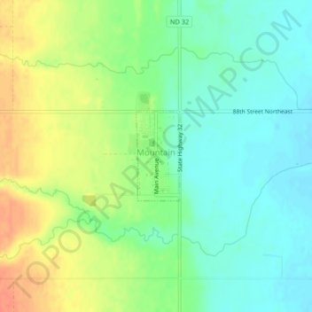
Naam: Topografische kaart Mountain, hoogte, reliëf.
Locatie: Mountain, Pembina County, North Dakota, United States (48.68020 -97.86786 48.68793 -97.86212)
Gemiddelde hoogte: 325 m
Minimale hoogte: 306 m
Maximale hoogte: 352 m
Mountain was officially laid out in 1884. The city was named on account of its lofty elevation. A post office called Mountain has been in operation since 1881. The Vikur Lutheran Church at Mountain was built in 1884.
Andere topografische kaarten
Klik op een kaart om zijn topografie, zijn hoogte en zijn reliëf te bekijken.
Drayton
United States > North Dakota > Pembina County
Drayton, Pembina County, North Dakota, 58225, United States
Gemiddelde hoogte: 242 m
Walhalla
United States > North Dakota > Pembina County
Walhalla, Pembina County, North Dakota, United States
Gemiddelde hoogte: 303 m
Pittsburgh
United States > North Dakota > Pembina County > Pittsburgh
Pittsburgh, Pembina County, North Dakota, United States
Gemiddelde hoogte: 243 m
Bathgate
United States > North Dakota > Pembina County > Bathgate
Bathgate, Pembina County, North Dakota, United States
Gemiddelde hoogte: 250 m