Topografische kaart Eaux-Bonnes
Interactieve kaart
Klik op de kaart om de hoogte weer te geven.
Over deze kaart
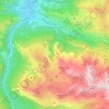
Naam: Topografische kaart Eaux-Bonnes, hoogte, reliëf.
Gemiddelde hoogte: 1.417 m
Minimale hoogte: 489 m
Maximale hoogte: 2.604 m

Klik op de kaart om de hoogte weer te geven.
Naam: Topografische kaart Eaux-Bonnes, hoogte, reliëf.
Gemiddelde hoogte: 1.417 m
Minimale hoogte: 489 m
Maximale hoogte: 2.604 m