

Doe een donatie
Rust jezelf uit voor je volgende avontuur:
Als Amazon-partner verdient deze site een commissie op in aanmerking komende aankopen, zonder extra kosten voor jou.
Topografische kaart Oludeniz
Klik op de kaart om de hoogte weer te geven.
Doe een donatie
Rust jezelf uit voor je volgende avontuur:
Als Amazon-partner verdient deze site een commissie op in aanmerking komende aankopen, zonder extra kosten voor jou.
Oludeniz
Ölüdeniz offer a variety of diving opportunities with regard to its crystal clear waters and rich underwater caves and fauna. Scuba diving is the most popular underwater activity. Local diving agencies provide courses and required scuba diving licences. Snorkelling is another diving activity and many sites are very suitable for snorkelling. Ölüdeniz (literally "Dead Sea", due to its calm waters even during storms; official translation: Blue Lagoon) is a town of the municipality and district of Fethiye, Muğla Province, Turkey. Its population is 6,132 (2022). Before the 2013 reorganisation, it was a town (belde). It is a beach resort on the Turkish Riviera, at the conjunction point of the Aegean and Mediterranean seas. It is located 14 km (9 mi) south of Fethiye, near Mount Babadağ. Ölüdeniz is also widely recognized for its exceptional conditions for paragliding, with flights launching from nearby Mount Babadağ—considered one of the best paragliding spots in the world due to its elevation and proximity to the sea.
Doe een donatie
Rust jezelf uit voor je volgende avontuur:
Als Amazon-partner verdient deze site een commissie op in aanmerking komende aankopen, zonder extra kosten voor jou.
Over deze kaart
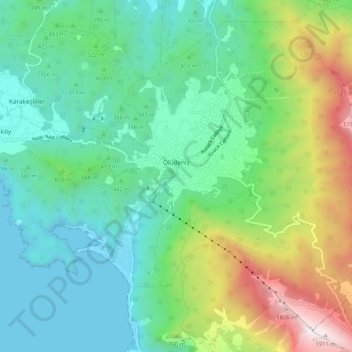
Naam: Topografische kaart Oludeniz, hoogte, reliëf.
Locatie: Oludeniz, Fethiye, Muğla, Aegean Region, Turkey (36.53030 29.10601 36.60440 29.21068)
Gemiddelde hoogte: 541 m
Minimale hoogte: 0 m
Maximale hoogte: 1.965 m
Doe een donatie
Rust jezelf uit voor je volgende avontuur:
Als Amazon-partner verdient deze site een commissie op in aanmerking komende aankopen, zonder extra kosten voor jou.
Andere topografische kaarten
Klik op een kaart om zijn topografie, zijn hoogte en zijn reliëf te bekijken.



Doe een donatie
Rust jezelf uit voor je volgende avontuur:
Als Amazon-partner verdient deze site een commissie op in aanmerking komende aankopen, zonder extra kosten voor jou.
